The world’s population exceeded 7.3 billion in 2015, showing an increase of nearly one billion people over 12 years of growth. A huge proportion of this population is focused within urban zones, with approximately 50% of people, some three billion, living in cities. Current trends show that the majority of future population growth will be centred in the urban environment.
Such a high proportion of people living in the urban environment emphasises the health issues unique to these areas. Rapid urbanisation has highlighted issues of pollution, poor air quality, heat risks and increased energy costs. Understanding these issues requires knowledge of the main physical processes associated with the urban environment.
The urban energy balance is the term given to the complex interplay of a number of critical processes that govern energy in the urban environment and impacts the mesoscale weather, and indirectly may influence the hydrology and ecology. It is a vital component of any model attempting to simulate dynamic/thermodynamic patterns above the surface.
Ongoing research in NCEO-Leicester is utilising land surface temperature (LST) data for mapping urban heat islands with a focus on routes to impact by the generation of informative indices. Current operational infrared satellite EO sensors typically offer highly accurate LST but their spatial resolutions are of order 1 km. Some higher spatial thermal imaging capability for LST measurement is available but their limited temporal sampling and lower accuracy restricts scientific advances and uptake of applications from these missions. In particular, accurate measurement of LST at local (< 100 m) scales to resolve city streets and knowledge of urban heating is lacking.
The cumulative research work of the Land Surface Temperature Group in NCEO-Leicester over a decade has been central to the European Space Agency (ESA) being able to define and implement Europe’s first, high spatial resolution, thermal infra-red mission. This mission, the Copernicus Land Surface Temperature Monitoring (LSTM) will be built to deliver operational services over cities. The challenge is to develop robust approaches to truly exploit the advantages of these higher resolution missions for mapping urban heating.
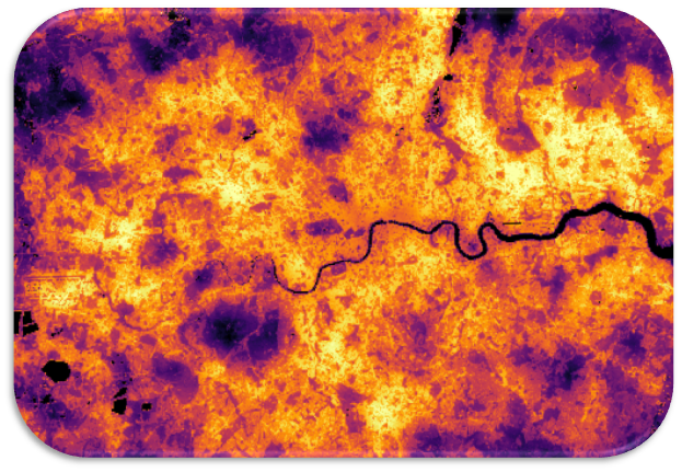
Figure 1: Land Surface Temperature (LST) view of London, UK, on 30 July 2024 from Sentinel 3a. The LST data have been downscaled using Vis/SWIR inputs from Landsat 9 and Sentinel 2a and a bottom-of-atmosphere optimal estimation methodology to refine the estimates from 1 km data to 100 m. Global Climate Chapter Cover Image from the “BAMS State of the Climate, 2024”. Image produced by the Land Surface Temperature Group in NCEO-Leicester.
This project is not suitable for CASE funding
Each host has a slightly different application process.
Find out how to apply for this studentship.
All applications must include the CENTA application form.
Choose your application route
This PhD looks to explore two key factors from remote sensing for quantifying urban heating: the ground heat flux; and the contribution of anthropogenic heat flux to the Urban Energy Balance. Thermal infra-red remote sensing can allow us to estimate the ground leaving radiation in the longwave, but this is a variable comprised of many different parts. Conventionally retrievals have only been able to break this down into two factors: Land Surface Temperature (LST) and Emissivity. The LST is the thermodynamic temperature of the satellite facing surface which emits the radiation, and the emissivity is the pixel aggregated emittance factor of the surface.
This work would look to utilise both downscaled and native resolution thermal data to integrate them into an urban energy model framework. This would provide a cutting edge assessment of urban heating as well as providing crucial inputs to climate adaptation and urban greening strategies.
DRs will be awarded CENTA Training Credits (CTCs) for participation in CENTA-provided and ‘free choice’ external training. One CTC can be earned per 3 hours training, and DRs must accrue 100 CTCs across the three and a half years of their PhD.
In the first year, students will be trained on environmental data science, research methods and core skills. Throughout the PhD, training will progress from core skills sets to master classes specific to this project’s themes. Specialist training will include sensor techniques, radiative transfer for infra-red and microwave, non-linear data methods and general remote sensing. The National Centre for Earth Observation will provide access to its Researcher Forum, staff conferences/workshops and national-level training. There is good access to international summer schools, and the student can gain experience from attending European Space Agency meetings and events.
This project will fall within the National Centre of Earth Observation (NCEO), which is the leading collective of satellite remote sensing in the UK. Furthermore, the project will feed directly into the preparations for a future high resolution thermal sensor, through the European Space Agency (ESA). The student will have a unique opportunity to work alongside the leading scientists across Europe and beyond in measuring the temperature of the Earth from space, and preparing for the upcoming Copernicus Land Surface Temperature Mission (LSTM). Specific collaborations on developing the methods with leading academic centres and world leading space industries.
Year 1 Training in software usage and development, and attendance at dedicated workshops. Initial evaluation of high resolution IR data and data analysis to produce a first high resolution LST dataset.
Year 2: Determination of robust relationships and construction of combined LST & Land Surface Emissivity retrieval algorithms and the urban energy balance model. Conference attendance, preparation of manuscript for journal submission. Continued development of thesis chapters.
Year 3: Advanced method for high resolution LST capable of identifying the anthropogenic heating in cities, modelling and design of climate adaption strategies for utilising space data over cities. Manuscript submission and revision, International conference attendance, thesis preparation.
Ghent, D. J., Anand, J. S., Veal, K., Remedios, J. J. (2024). The operational and climate land surface temperature products from the Sea and Land Surface Temperature Radiometers on Sentinel-3A and 3B. Remote Sensing, 16, 3403. https://doi.org/10.3390/rs16183403
Ghent, D., Veal, K., Trent, T., Dodd, E., Sembhi, H., and Remedios, J. (2019). A New Approach to Defining Uncertainties for MODIS Land Surface Temperature. Remote Sensing, 11, 1021
Good, E., Blannin, B., Waring, A., Veal, K., and Ghent, D., (2025). Sidebar 2.1: Super extreme land surface temperature hotspots, [in “State of the Climate in 2024”]. Bull. Amer. Meteor. Soc., 106 (8), S37–S39, https://doi.org/10.1175/BAMS-D-25-0102.1
Hulley, G., Veraverbeke, S., and Hook, S., Thermal-based techniques for land cover change detection using a new dynamic MODIS multispectral emissivity product (MOD21), (2014). Remote Sensing of Environment, 140, 755-765, doi:10.1016/j.rse.2013.10.014.
Perry, M. J. S. (2017). High Spatial Resolution Retrieval of LST and LSE for the Urban Environment (Doctoral dissertation, Department of Physics and Astronomy). https://leicester.figshare.com/articles/thesis/High_Spatial_Resolution_Retrieval_of_LST_and_LSE_for_the_Urban_Environment/10231151
BBC News (2022) ‘UK also broke its land surface temperature record’. Available at: https://www.bbc.co.uk/news/science-environment-62257163
Dr Darren Ghent is the lead scientist on the international Climate Change Initiative LST Project, and leads the LST activities for the operational Sentinel-3 satellite mission and the upcoming LSTM mission. The student will have a chance to be part of a national EO community complementing the environmental science focus of CENTA. Professor Remedios is Director of NCEO and Professor at University of Leicester. NCEO is a national centre funded by NERC and distributed across key Earth Observation (EO) groups at Universities and research laboratories.
For any enquiries related to this project please contact Dr Darren Ghent, NCEO Leicester, [email protected].
To apply to this project:
Applications must be submitted by 23:59 GMT on Wednesday 7th January 2026.