Indonesia is among the most exposed regions globally to volcanic hazards. Among these hazards, volcanic tsunamis present a particular challenge and have been the cause of several disasters in the past two centuries. Part of the challenge of managing volcanic tsunami hazards lies in the complexity of potential sources and the unpredictability of their timing and size. Maintaining awareness for these low-frequency but potentially extreme-magnitude events, and incorporating these events into hazard management planning, is a further challenge. Adding to these factors, the areas most at risk from volcanic tsunamis are isolated small-island sites in eastern and northern Indonesia, which have limited baseline geological knowledge of past events. This project will address these challenges by:
Collectively, this approach aims to bridge the current gap between the outputs of research focused studies of volcanic tsunami risk, mechanisms and scenarios, and how effectively these outputs inform and support volcanic-tsunami monitoring and hazard management plans. By undertaking this work in Indonesia, a region with multiple island volcanoes and an extensive history of past volcanic tsunamis, the project also aims to develop research approaches and to develop guidance that can support more effective volcanic-tsunami risk evaluations in other vulnerable parts of the world.
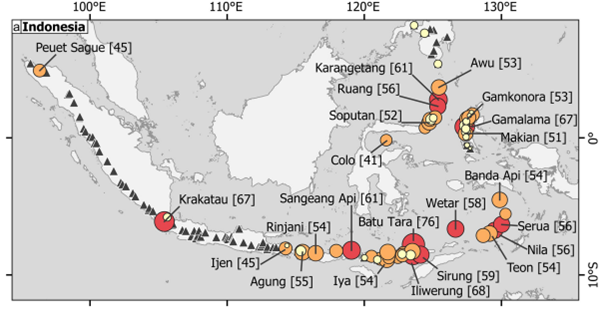
Figure 1: Current ranking-based evaluation of tsunami risk in Indonesia, from Zorn et al., 2022, highlighting tsunami potential across multiple island sites in eastern Indonesia.
This project is not suitable for CASE funding
Each host has a slightly different application process.
Find out how to apply for this studentship.
All applications must include the CENTA application form.
Choose your application route
The project will involve various data types and collection methods:
DRs will be awarded CENTA Training Credits (CTCs) for participation in CENTA-provided and ‘free choice’ external training. One CTC can be earned per 3 hours training, and DRs must accrue 100 CTCs across the three and a half years of their PhD.
Training will be provided directly within the project in a variety of methods, drawing on guidance from the supervisory team and through interactions with Indonesian research partners. This includes training in field data collection; interpretation of physical volcanic processes, including tsunami mechanisms; database construction and analysis; and qualitative data collection and analysis methods for evaluation of hazard management and awareness.
The supervisory team includes partnership from the British Geological Survey, from members of the hazards and risk team. The partnership brings in project-relevant volcanological and interdisciplinary expertise, including in hazard and vulnerability assessment, multi-hazard processes and social science methods applied to volcanology.
Year 1: Compilation and analysis of archival datasets; regional evaluations and geomorphological analyses; fieldwork planning and preparation; Indonesian agency engagement. Fieldwork near end of Year 1.
Year 2: Analysis of field datasets, including geological sample and field survey data and community surveying. Development of regional scale reassessment of tsunami risk; preparation of manuscripts for local field-study sites and national tsunami risk evaluation.
Year 3: Finalisation of manuscripts; evaluation of hazard management protocols and development of recommendations; publication of final manuscript/technical report in collaboration with Indonesian partners.
Grilli, S.T., Tappin, D.R., Carey, S., Watt, S.F., Ward, S.N., Grilli, A.R., Engwell, S.L., Zhang, C., Kirby, J.T., Schambach, L. and Muin, M., 2019. Modelling of the tsunami from the December 22, 2018 lateral collapse of Anak Krakatau volcano in the Sunda Straits, Indonesia. Scientific reports, 9(1), p.11946.
Pranantyo, I.R., Heidarzadeh, M. and Cummins, P.R., 2021. Complex tsunami hazards in eastern Indonesia from seismic and non-seismic sources: Deterministic modelling based on historical and modern data. Geoscience Letters, 8(1), p.20.
Zorn, E.U., Orynbaikyzy, A., Plank, S., Babeyko, A., Darmawan, H., Robbany, I.F. and Walter, T.R., 2022. Identification and ranking of subaerial volcanic tsunami hazard sources in Southeast Asia. Natural Hazards and Earth System Sciences, 22(9), pp.3083-3104.
Please contact Seb Watt on [email protected] for further information.
To apply to this project:
Applications must be submitted by 23:59 GMT on Wednesday 7th January 2026.