

Cities are on the frontline of climate change. Identifying where and when extreme heat occurs enables policymakers to reduce health risks, strengthen infrastructure resilience, and target adaptation measures where they are needed most. Land Surface Temperature (LST) is a key indicator of land-atmosphere interactions and plays an important role in understanding drought, heatwaves, ecosystem functioning and urban climate processes. High spatial resolution LST observations are particularly valuable in cities, where sharp thermal contrasts can occur over distances of tens to hundreds of metres because of differences in building materials, vegetation cover, shading, surface wetness and urban form. However, satellite observations generally involve a trade-off between spatial and temporal resolution, limiting our ability to monitor these fine-scale thermal patterns as they evolve through heatwaves and other periods of environmental stress.
This project tests whether high-resolution LST downscaling can be made more physically robust and more useful for urban heat monitoring by adding dynamic information on surface wetness, vegetation condition and recent meteorological forcing to an emissivity-based retrieval framework.
Current downscaling approaches seek to bridge this gap by combining moderate-resolution thermal observations with higher-resolution optical information. Within the proposed Sentinel-3 and Sentinel-2 framework, higher-resolution information is introduced through Sentinel-2-derived land surface emissivity (LSE), with LST subsequently refined using an Optimal Estimation approach. The methodology uses spectral information from the visible, near-infrared and short-wave infrared channels to classify the surface and derive emissivity fields that contain substantially greater spatial detail than the original thermal observations.
The cumulative research work of the Land Surface Temperature Group in NCEO-Leicester over a decade has been central to the European Space Agency (ESA) being able to define and implement Europe’s first, high spatial resolution, thermal infra-red mission. This mission, the Copernicus Land Surface Temperature Monitoring (LSTM) will be built to deliver operational services over cities.
The project is expected to deliver evidence on when dynamic environmental information improves LST downscaling for urban heat applications to improve climate resilience, neighbourhood-scale heat-risk assessment, green and blue infrastructure evaluation, ecosystem monitoring and environmental change analysis.
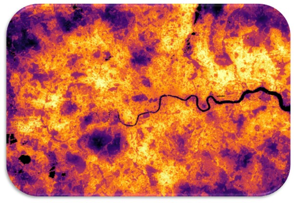
Figure 1: Land Surface Temperature (LST) view of London, UK, on 30 July 2024 from Sentinel 3a. The LST data have been downscaled using Vis/SWIR inputs from Landsat 9 and Sentinel 2a and a bottom-of-atmosphere optimal estimation methodology to refine the estimates from 1 km data to 100 m. Global Climate Chapter Cover Image from the “BAMS State of the Climate, 2024”. Image produced by the Land Surface Temperature Group in NCEO-Leicester.
This project does not offer a CASE studentship
Each host has a slightly different application process.
Find out how to apply for this studentship.
All applications must include the CENTA application form.
Choose your application route
The project will integrate Sentinel-1, Sentinel-2 and Sentinel-3 observations, alongside meteorological reanalysis products. Existing LST downscaling approaches will be used as a baseline before progressively incorporating dynamic environmental information relevant to urban heat processes, such as surface wetness, vegetation condition, antecedent weather and evaporative cooling potential. Machine learning and neural-network methods will be used to evaluate candidate variables, test non-linear interactions and determine which combinations provide robust and physically meaningful improvements to the downscaling framework.
Model performance will be evaluated against independent observations where available, with particular focus on whether the dynamic constraints improve urban-scale interpretation of:
The work will combine remote sensing, environmental physics, machine learning, statistical modelling and uncertainty analysis, giving the student experience in both algorithm development and the interpretation of urban environmental change from satellite data.
DRs will be awarded CENTA Training Credits (CTCs) for participation in CENTA-provided and ‘free choice’ external training. One CTC can be earned per 3 hours training, and DRs must accrue 100 CTCs across the three and a half years of their PhD.
In the first year, students will be trained on environmental data science, research methods and core skills. Throughout the PhD, training will progress from core skills sets to master classes specific to this project’s themes. Specialist training will include sensor techniques, radiative transfer for infra-red and microwave, non-linear data methods, AI and machine learning, statistical modelling and general remote sensing. The National Centre for Earth Observation will provide access to its Researcher Forum, staff conferences/workshops and national-level training. There is good access to international summer schools, and the student can gain experience from attending European Space Agency meetings and events.
This project will fall within the National Centre of Earth Observation (NCEO), which is the leading collective of satellite remote sensing in the UK. Furthermore, the project will feed directly into the preparations for a future high resolution thermal sensor, through the European Space Agency (ESA). The student will have a unique opportunity to work alongside the leading scientists across Europe and beyond in measuring the temperature of the Earth from space, and preparing for the upcoming Copernicus Land Surface Temperature Mission (LSTM). Specific collaborations on developing the methods with leading academic centres and world leading space industries.
Year 1 Training in software usage and development, and attendance at dedicated workshops. Initial evaluation of high resolution thermal data and data analysis to implement and assess an emissivity-based downscaling framework using Sentinel-3 thermal observations and Sentinel-2-derived surface classification and emissivity products.
Year 2: Determination of robust relationships for a range of candidate variables with relevance to both surface energy balance and urban heat processes using machine learning and neural-network methods. To distinguish thermally persistent hot surfaces from locations where moisture availability, vegetation condition or recent weather produce more variable cooling effects. Conference attendance, preparation of manuscript for journal submission. Continued development of thesis chapters.
Year 3: Advanced method for dynamic thermal downscaling capable of mapping heating events in cities as a utility for modelling and design of climate adaption strategies for cities. Assessment will be focused on periods of rapid environmental change such as drought development, irrigation events and heatwaves. Manuscript submission and revision, International conference attendance, thesis preparation.
Ghent, D. J., Anand, J. S., Veal, K., Remedios, J. J. (2024). The operational and climate land surface temperature products from the Sea and Land Surface Temperature Radiometers on Sentinel-3A and 3B. Remote Sensing, 16, 3403. https://doi.org/10.3390/rs16183403
Ghent, D., Veal, K., Trent, T., Dodd, E., Sembhi, H., and Remedios, J. (2019). A New Approach to Defining Uncertainties for MODIS Land Surface Temperature. Remote Sensing, 11, 1021
Good, E., Blannin, B., Waring, A., Veal, K., and Ghent, D., (2025). Sidebar 2.1: Super extreme land surface temperature hotspots, [in “State of the Climate in 2024”]. Bull. Amer. Meteor. Soc., 106 (8), S37–S39, https://doi.org/10.1175/BAMS-D-25-0102.1
Hulley, G., Veraverbeke, S., and Hook, S., Thermal-based techniques for land cover change detection using a new dynamic MODIS multispectral emissivity product (MOD21), (2014). Remote Sensing of Environment, 140, 755-765, doi:10.1016/j.rse.2013.10.014.
Perry, M. J. S. (2017). High Spatial Resolution Retrieval of LST and LSE for the Urban Environment (Doctoral dissertation, Department of Physics and Astronomy). https://leicester.figshare.com/articles/thesis/High_Spatial_Resolution_Retrieval_of_LST_and_LSE_for_the_Urban_Environment/10231151
BBC News (2022) ‘UK also broke its land surface temperature record’. Available at: https://www.bbc.co.uk/news/science-environment-62257163
For any enquiries related to this project please contact Dr Darren Ghent, [email protected].
Dr Darren Ghent is the lead scientist on the international Climate Change Initiative LST Project, and leads the LST activities for the operational Sentinel-3 satellite mission and the upcoming LSTM mission. The student will have a chance to be part of a national EO community complementing the environmental science focus of CENTA. Dr Robert Parker is Lecturer in Earth Observation and UKRI Future Leader Fellow and is principal investigator on multiple Digital Twin studies.
To apply to this project:
Applications must be submitted by 23:59 GMT on Wednesday 6th January 2027.