

Mineral dust emissions play a fundamental role in global climate dynamics, ocean biogeochemistry, and air quality (Middleton & Goudie, 2026). Their impact depends on source properties—including geochemistry (Kunkelova et al., 2022), mineralogy (Mangum et al., 2024), and microclimates governing emission flux and transport (Duran et al., 2011). However, direct observations remain constrained as source areas are predominantly remote, with ground stations capturing events hours or days post-emission (Wiggs et al., 2022). Better modelling of dust emissions is therefore essential to understanding their response to changing climate drivers.
Existing approaches face key trade-offs. Earth Observation (EO) methods infer dust sources via manual tracking (Hennen et al., 2019; Nobakht et al., 2020) or statistical proxies (Ginoux et al., 2004; Mohammadpour et al., 2022), but are computationally intensive and prone to false positives from surfaces spectrally similar to dust plumes (Ashpole and Washington, 2013; AlNasser and Entekhabi, 2024). Conversely, physically based models simulate emissions from wind friction velocities (Chappell et al., 2023a) but carry high uncertainty because sediment availability and peak surface winds cannot be resolved at dust-emission scales (Chappell et al., 2023b; Hennen et al., 2024).
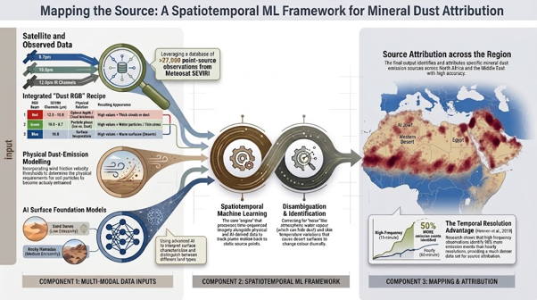
This project will build a framework combining satellite EO, physical modelling, and machine learning (ML) to locate and attribute dust emission sources (Figure 1). The student will develop an offline image classifier using Bayes Theorem, building on the approach of Bulgin et al. (2022) by applying statistical methods to identify dust in hourly SEVIRI thermal infrared (TIR) observations. Classifier performance will be evaluated against >27,000 dust point-source observations (Hennen et al., 2017). Physically based emission modelling will characterise wind and surface conditions to predict dust-emitting conditions probabilistically. These streams will be integrated within a spatiotemporal ML architecture to track plume evolution and pinpoint emission locations and timing.
The resulting framework will provide a robust observational baseline of dust emission sources across North Africa and the Middle East. These data will enable the PhD candidate to investigate how the location and frequency of dust emissions respond to environmental controls, including changing hydrology (rainfall and soil moisture), vegetation patterns (abundance and type), and surface disturbance (land use and extreme weather events, such as wildfire).
Figure 1: The three component stages of the spatiotemporal framework for mineral dust source mapping and characterisation.
This project does not offer a CASE studentship
Each host has a slightly different application process.
Find out how to apply for this studentship.
All applications must include the CENTA application form.
Choose your application route
This project follows a four-stage workflow:
DRs will be awarded CENTA Training Credits (CTCs) for participation in CENTA-provided and ‘free choice’ external training. One CTC can be earned per 3 hours training, and DRs must accrue 100 CTCs across the three and a half years of their PhD.
The candidate will develop interdisciplinary skills across Earth Observation (EO), computational modelling and AI. Training will cover high-performance computing (HPC), satellite atmospheric retrievals, geospatial data integration, machine learning, computer vision and quantitative model validation. The student will gain expertise in processing large satellite datasets, running physically based dust-emission models and applying AI to spatiotemporal environmental data. Transferable skills will include scientific writing, publishing research, communicating findings to diverse audiences, presenting at conferences and developing research collaborations. This combination of technical and professional training will support successful project delivery and prepare the candidate for research and applied environmental careers.
NCEO will contribute expertise in Earth observation, surface temperature retrieval, image classification and radiative transfer through co-supervision, while Cardiff University will provide expertise in Earth-system modelling and dust-emission processes. The PhD student will have opportunities to engage with the wider NCEO community through annual conferences and PhD training, alongside engagement with Cardiff researchers working on environmental modelling and land–atmosphere interactions. Where appropriate, short research visits may be arranged with partner researchers, providing additional training and opportunities to develop wider collaborative networks. Together, these partnerships will connect the project to the wider UK Earth observation and Earth-system modelling research communities.
The project will be structured around three research papers that will form the basis of the PhD thesis, with the aim of having at least one or two papers published or under review for publication by the end of the studentship. The first two years will focus on developing and validating the methodological framework, progressing from automated dust detection to the integration of Earth observation and physically based modelling. The final year will provide the PhD candidate with the opportunity to apply the framework to an Earth-system research question of their choice, investigating how dust emission responds to dynamic environmental processes.
| Year | Research focus | Key outputs |
| Year 1 – Automated dust detection | Develop and validate a machine-learning framework for automated detection and tracking of dust plumes from hourly Meteosat SEVIRI observations.
Initial development will focus on a well-characterised study region such as Mesopotamia, using the existing >27,000 georeferenced dust-source observations for training and validation. |
Paper 1: Automated detection of mineral dust emissions reveals the dynamic evolution of dust sources in Mesopotamia |
| Year 2 – Integrating observations and physical modelling | Extend the automated retrieval and integrate it with the physically based dust-emission model.
Cross-validation between observed emissions and modelled emission potential will identify false positives, assess model strengths and weaknesses, and improve attribution of dust plumes to their most probable upwind sources. |
Paper 2: Integrating satellite observations and physical modelling to constrain mineral dust emission sources |
| Year 3 – Earth-system application | Apply the integrated framework across North Africa and the Middle East to produce a high-temporal-resolution dust-source inventory.
The PhD candidate will then develop a focused research question linking dust-emission activation and dynamic environmental controls, with scope to investigate vegetation, hydrology/fluvial processes, atmospheric conditions or surface disturbance. |
Paper 3: Student-led investigation of the environmental controls on dust-source activation; PhD thesis and final dust-source inventory |
Journal:
Hennen, M., White, K. and Shahgedanova, M. (2019) ‘An assessment of SEVIRI imagery at various temporal resolutions and the effect on accurate dust emission mapping’, Remote Sensing, 11(8), 918. doi:10.3390/rs11080918
Chappell, A., Webb, N.P., Hennen, M., Zender, C., Ciais, P., Schepanski, K., Edwards, B., Ziegler, N., Balkanski, Y., Tong, D., Leys, J., Heidenreich, S., Hynes, R., Fuchs, D., Zeng, Z., Baddock, M., Lee, J. and Kandakji, T. (2023b) ‘Elucidating hidden and enduring weaknesses in dust emission modelling’, Journal of Geophysical Research: Atmospheres, 128. doi:10.1029/2023JD038584
Bulgin, C.E.; Embury, O.; Maidment, R.I.; Merchant, C.J. Bayesian Cloud Detection over Land for Climate Data Records. Remote Sens. 2022, 14, 2231. https://doi.org/10.3390/rs14092231
Proposal References
AlNasser, F. and Entekhabi, D. (2024) ‘DustSCAN: A five year (2018–2022) hourly dataset of dust plumes from SEVIRI’, Scientific Data, 11, 607. doi:10.1038/s41597-024-03452-4
Ashpole, I. and Washington, R. (2013) ‘A new high-resolution central and western Saharan summertime dust source map from automated satellite dust plume tracking’, Journal of Geophysical Research: Atmospheres, 118, pp. 6981–6995. doi:10.1002/jgrd.50554
Chappell, A., Webb, N.P., Hennen, M., Schepanski, K., Ciais, P., Balkanski, Y., Zender, C., Tegen, I., Zeng, Z., Tong, D., Baker, B., Ekström, M., Baddock, M., Eckardt, F., Kandakji, T., Lee, J., Nobakht, M., von Holdt, J. and Leys, J. (2023a) ‘Satellites reveal Earth’s seasonally shifting dust emission sources’, Science of the Total Environment, 883, 163452. doi:10.1016/j.scitotenv.2023.163452
Chappell, A., Webb, N.P., Hennen, M., Zender, C., Ciais, P., Schepanski, K., Edwards, B., Ziegler, N., Balkanski, Y., Tong, D., Leys, J., Heidenreich, S., Hynes, R., Fuchs, D., Zeng, Z., Baddock, M., Lee, J. and Kandakji, T. (2023b) ‘Elucidating hidden and enduring weaknesses in dust emission modelling’, Journal of Geophysical Research: Atmospheres, 128. doi:10.1029/2023JD038584
Durán, O., Claudin, P. and Andreotti, B. (2011) ‘On aeolian transport: Grain-scale interactions, dynamical mechanisms and scaling laws’, Aeolian Research, 3(3), pp. 243–270. doi:10.1016/j.aeolia.2011.07.006
Ginoux, P., Prospero, J.M., Gill, T.E., Hsu, N.C. and Zhao, M. (2012) ‘Global-scale attribution of anthropogenic and natural dust sources and their emission rates based on MODIS Deep Blue aerosol products’, Reviews of Geophysics, 50, RG3005. doi:10.1029/2012RG000388
Hennen, M. (2017) ‘Identifying mineral dust emission sources in the Middle East using remote sensing techniques’. PhD thesis, University of Reading. University of Reading record
Hennen, M., White, K. and Shahgedanova, M. (2019) ‘An assessment of SEVIRI imagery at various temporal resolutions and the effect on accurate dust emission mapping’, Remote Sensing, 11(8), 918. doi:10.3390/rs11080918
Hennen, M., Chappell, A., Webb, N.P., Schepanski, K., Baddock, M.C., Eckardt, F.D., Kandakji, T., Lee, J.A., Nobakht, M. and von Holdt, J. (2024) ‘A new framework for evaluating dust emission model development using dichotomous satellite observations of dust emission’, Science of the Total Environment, 912, 169237. doi:10.1016/j.scitotenv.2023.169237
Mangum, A.L., Carling, G.T., Bickmore, B.R., Webb, N., Leifi, D.L., Brahney, J., Fernandez, D.P., Rey, K.A., Nelson, S.T., Burgener, L., LeMonte, J.J., Thompson, A.N., Newingham, B.A., Duniway, M.C. and Aanderud, Z.T. (2024) ‘Characterizing variability in geochemistry and mineralogy of western US dust sources’, Aeolian Research, 70–71, 100941. doi:10.1016/j.aeolia.2024.100941
Mohammadpour, K., Rashki, A., Sciortino, M., Kaskaoutis, D.G. and Darvishi Boloorani, A. (2022) ‘A statistical approach for identification of dust-AOD hotspots climatology and clustering of dust regimes over Southwest Asia and the Arabian Sea’, Atmospheric Pollution Research, 13(4), 101395. doi:10.1016/j.apr.2022.101395
Nobakht, M., Shahgedanova, M. and White, K. (2021) ‘New inventory of dust emission sources in Central Asia and Northwestern China derived from MODIS imagery using dust enhancement technique’, Journal of Geophysical Research: Atmospheres, 126(4), e2020JD033382. doi:10.1029/2020JD033382
Schepanski, K., Tegen, I. and Macke, A. (2012) ‘Comparison of satellite based observations of Saharan dust source areas’, Remote Sensing of Environment, 123, pp. 90–97. doi:10.1016/j.rse.2012.03.019
Wiggs, G.F.S., Baddock, M.C., Thomas, D.S.G., Washington, R., Nield, J.M., Engelstaedter, S. et al. (2022) ‘Quantifying mechanisms of aeolian dust emission: Field measurements at Etosha Pan, Namibia’, Journal of Geophysical Research: Earth Surface, 127, e2022JF006675. doi:10.1029/2022JF006675
For any enquiries related to this project please contact:
| Dr Mark Hennen | [email protected] | The Open University |
| Dr Claire Bulgin | [email protected] | NCEO / University of Reading |
| Prof. Adrian Chappell | [email protected] | Cardiff University |
| Prof. Toni Gladding | [email protected] | The Open University |
To apply to this project:
You should make your application via The Open University’s applications portal. If you do not already have an account for this portal, you will need to register your interest and will be prompted to create an account. As part of your application, you will need to provide:
Applications must be submitted by 23:59 GMT on Wednesday 6th January 2027.