Under climate change, permafrost carbon emissions could be large enough to create considerable impacts on the climate system. The representation of processes leading to permafrost carbon emissions in climate models is incomplete – the current representation typically looks at the gradual thawing of the soil and the gradual increased exposure of the carbon to decomposition. However, faster landscape transitions, such as thaw slumps, collapse scars and changes in thermokarst lakes will also impact the northern high latitudes carbon cycle. These are poorly, if at all, represented in Earth System models. It has been suggested that including abrupt thaw process in the permafrost region could be equivalent to that from gradual thaw processes under future climate change, but this estimate has huge uncertainties. These abrupt processes accelerate thaw rates at the local scale and are essentially irreversible on human timescales. Here we propose to use Earth Observation to detect and quantify abrupt thaw transitions. We are entering a period with an unprecedented wealth of satellite missions measuring the planet. The growth in the quantity and capability of satellite observations offers an excellent opportunity to evaluate and constrain these processes and their feedbacks on the climate. There has also been a recent step-change in the areas of machine learning and data assimilation. This project will explore these state-of-the-art methods for bringing together large volumes of satellite observations with highly complex climate model output, leading to opportunities for developing novel analysis. We will use this data alongside model output from the Joint UK Land Environment Simulator (JULES) to create a data informed model of abrupt thaw. This approach can then be included in the United Kingdom Earth System Model and used to explore reversibility and tipping points using future climate projections.
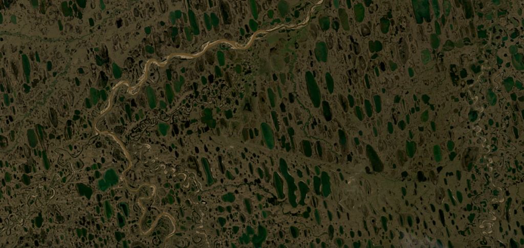
Figure 1: Satellite imagery showing the complex Arctic landscape, dominated by thermokarst lakes produced by thawing permafrost causing land deformation.
This project is a CENTA Flagship Project.
This project is suitable for CASE funding
Each host has a slightly different application process.
Find out how to apply for this studentship.
All applications must include the CENTA application form.
Choose your application route
We plan to use advanced machine-learning methods such as UNET to perform image segmentation and classification on satellite imagery in order to identify and monitor landscape changes in the Arctic, such as thermokarst lake formation, with the intention of monitoring for early warning signals of a potential climate tipping point.
At the same time, we will use Earth Observation data to evaluate the capabilities of state-of-the-art land surface models (e.g. JULES – https://jules.jchmr.org/) to understand how model performance can be improved to better represent fast landscape transitions (e.g. permafrost thaw-driven collapse).
By identifying and improving relevant model processes, we will increase the utility of the model to produce future climate projections, assessing the model output for behaviour characteristic of irreversible change.
DRs will be awarded CENTA Training Credits (CTCs) for participation in CENTA-provided and ‘free choice’ external training. One CTC can be earned per 3 hours training, and DRs must accrue 100 CTCs across the three and a half years of their PhD.
NCEO will provide access to its Researcher Forum, staff conferences/workshops and national-level training.
There will be opportunity for the student to receive training at the UK Met Office related to using and analysing the UK Earth System Model and the JULES land-surface model component.
Training will be provided to the student by NCEO on the Earth System Model Evaluation Tool (ESMValTool).
The student will be trained in processing on the ALICE (University of Leicester) and JASMIN (NERC) supercomputer facilities.
This project will be based at University of Leicester, co-supervised by NCEO staff (Dr Darren Ghent and Dr Khunsa Fatima), bringing expertise on land surface temperature and machine learning, respectively. The supervisory team also includes Dr Noah Smith, University of Exeter and Dr Eleanor Burke, Met Office (via CASE support) who both bring expertise in JULES land surface modelling, specifically around permafrost.
We are also involved in multiple relevant projects including European Space Agency activities on climate change observations (ESA-CCI), tipping points (ESA-PREDICT) and Arctic methane/permafrost (ESA-AMPAC) which will allow the student opportunities to interact with the wider permafrost community.
Year 1: Literature review and refinement of research questions. Training and familiarisation with JULES land surface mode, initial JULES simulations using the ISMIP framework. Training regarding machine learning image segmentation.
Year 2: Development of code and analysis to incorporate new satellite observations and JULES output, making use of ESMValTool software. Journal publication aimed at evaluation of JULES output using range of Earth Observation data.
Year 3: Analysis of JULES driven with ISIMIP future climate scenarios. Journal publication aimed at climate impacts related to key science questions.
Bartsch et al., Advancing the Arctic Methane Permafrost Challenge (AMPAC) With Future Satellite Missions, in IEEE Journal of Selected Topics in Applied Earth Observations and Remote Sensing, vol. 18, pp. 6279-6298, https://doi.org/10.1109/JSTARS.2025.3538897, 2025
Brovkin, V. et al., Permafrost and Freshwater Systems in the Arctic as Tipping Elements of the Climate System, Surv Geophys 46, 303–326, https://doi.org/10.1007/s10712-025-09885-9, 2025
Lenton, T.M. et al., Remotely sensing potential climate change tipping points across scales, Nat Commun 15, 343, https://doi.org/10.1038/s41467-023-44609-w, 2024
Miner, K.R. et al., Permafrost carbon emissions in a changing Arctic, Nat Rev Earth Environ 3, 55–67, https://doi.org/10.1038/s43017-021-00230-3, 2022
Smith, N. D. et al., Explicitly modelling microtopography in permafrost landscapes in a land surface model (JULES vn5.4_microtopography), Geosci. Model Dev., 15, 3603–3639, https://doi.org/10.5194/gmd-15-3603-2022, 2022.
We would very strongly encourage anyone considering an application to get in touch with us in advance for an informal chat about the project at an early stage.
Please contact us at: Dr Robert Parker – University of Leicester – [email protected]
To apply to this project:
Applications must be submitted by 23:59 GMT on Wednesday 7th January 2026.