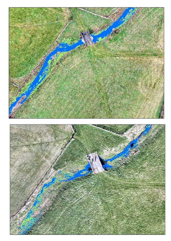
Intermittent streams (c. 50% of world rivers) and headwaters (c. 90% of rivers) are key riverine systems for hydrology, ecology and water quality, which are poorly monitored and lack data (Dugdale et al. 2022; Mainstone et al. 2018; Datry et al. 2016). Streams are often flagged as intermittent based on downstream flows, but where or how they dry is not known. Capturing the evolution of river habitat and connectivity as streams dry out is particularly important (Dugdale et al. 2022) for process hydrology, river ecology (e.g. refugia during drought, loss of physical in-channel habitat, loss of longitudinal connectivity, loss of lateral connectivity with riparian area, floodplain and wetlands), and water quality (pools are considered to favour algae blooms). Unpiloted Aerial Vehicles (UAVs), more commonly called drones, are a potential way to address these issues (Kelleher et al. 2016). River habitat monitoring can also benefit from using UAV data, which can provide fast higher resolution updates than traditional techniques. Figure 1 shows an example of mapping an intermittent chalk river in the UK. This research is relevant to other water-dependent systems faced with similar issues (e.g. wetlands) and could complement research on UAV-based water quality surveys in larger rivers. Beyond the riverine environment, the project would also explore potential to link with terrestrial UAV applications (e.g. biodiversity).
While the primary focus of this project in on headwaters and intermittent streams, the techniques and approaches developed by the student could be explored within the context of other river types or topics (e.g. thermal regime of contrasting river typologies or of groundwater-fed systems, mapping thermal refugia, longitudinal temperature change).
Figure 1: Drone-based mapping of a stretch on the intermittent river Beane, near Luffenhall, UK showing the loss of habitat between wetter conditions (14/12/24; top) and drier conditions (26/03/24; bottom); map was derived by combining unsupervised classifications of the RGB, TIR and DSM orthomosaics; blue, open flowing water class, green, emerging macrophytes/vegetated deposits class; map superimposed on the RGB orthomosaic.
This project is a CENTA Flagship Project.
This project is not suitable for CASE funding
Each host has a slightly different application process.
Find out how to apply for this studentship.
All applications must include the CENTA application form.
Choose your application route
A selection of river stretches located on small intermittent rivers will be surveyed as they dry and replenish (re-wetting) during a typical drought cycle. This ideally requires repeated surveys at high, medium, and low flows plus at least a couple of surveys during the intermittent phase. The total number of sites and surveys will be commensurate with the available time and resources. Sites will be surveyed on the ground too. The objective is to build a time series of surveys ideally capturing several cycles. Different types of drone-mounted sensors will tested, with likely types being optical, TIR, and multi-spectral cameras. They will be assessed not only from a scientific perspective but also against the context of future data collection (e.g. potential for citizen science). A consistent image classification approach will be developed. Possible route could be combining thermal imagery and very high-resolution visible imagery followed by AI-based classification to identify and segment the different habitat units. Developing an AI classifier would require using Python packages like PyTorch (e.g. Carbonneau et al., 2020a, 2020b). The supervision team is currently involved in a variety of active projects on these topics (e.g. looking at intermittent chalk rivers for a water company) and the student will be able to capitalise on this experience. We also have our own pool of drones, which will be available for the project.
DRs will be awarded CENTA Training Credits (CTCs) for participation in CENTA-provided and ‘free choice’ external training. One CTC can be earned per 3 hours training, and DRs must accrue 100 CTCs across the three and a half years of their PhD.
The student will benefit from access to the full portfolio of trainings available to UKCEH staff, from technical skills to personal professional development. Relevant trainings to this project will likely include advanced coding and data analysis (e.g. R, Python), statistics, machine learning, GIS, remote sensing software, field work practices, first aid. The student would be supported to learn how to pilot UAVs as far as practical and appropriate (e.g. working towards a GVC) but would get support from qualified pilots in the interim.
CENTA external partner Natural England (NE) will contribute to the project, which will benefit from the expertise of Vicki Howden, Senior Specialist Running Waters, Chief Scientist Directorate. NE can provide some operational and ground-based experience and knowledge, access to specialists, sites, data and reports of relevance to the project. It can provide a route to feed project data and findings to government advisory panels and other stakeholders or key partners to maximise impact. For NE, the project will contribute to a fundamental understanding of running rivers, which will link to many of its activities.
This project benefits from an on-going collaboration with Dr Steve Dugdale, University of Nottingham, whose area of expertise are UAV and thermal imagery in physical geography.
Year 1: Site selection; flight campaign planning; test surveys; initial image analysis and survey protocol; literature review
Year 2: Repeated surveys; development and consolidation of image processing approach; initial analysis of mapped geodata
Year 3: Final surveys; comparison UAV and alternative EO data (e.g Lidar); final analysis of mapped geodata.
Carbonneau, P., Belleti, B., Micotti, M., Lastoria, B., Casaioli, M., Mariani, S., Marcheti, G., and Bizzi, S. (2020) ‘UAV-based training for fully fuzzy classification of Sentinel-2 fluvial scenes’. Earth Surf. Process. Landforms, 45, 3120–3140.
Carbonneau, P., Dugdale, S., Breckon, T, Dietrich, J., Fonstad, M., Miyamoto, H., Woodget, A. (2020) ‘Adopting deep learning methods for airborne RGB fluvial scene classification’. Remote Sensing of Environment, 251.
Datry, T., Corti, R., Foulquier, A., von Schiller, D., and Tockner, K. (2016) ‘One for all, all for one: A global river research network’, Eos, 97, https://doi.org/10.1029/2016EO053587.
Dugdale, S., Klaus, J., and Hannah, D. (2022) ‘Looking to the skies: Realizing the combined potential of drones and thermal infrared imagery to advance hydrological process understanding in headwaters’. Water Res Research, 58.
Kelleher, C., Scholz, C. A., Condon, L., and Reardon, M. (2018) ’Drones in geoscience research: The sky is the only limit’, Eos, 99, https://doi.org/10.1029/2018EO092269.
Mainstone, C. et al. (2018) Developing a coherent framework for assessing priority freshwater habitats in England. Natural England JP016.
Please contact Dr Cedric Laize FRGS ([email protected]).
The successful applicant would be registered at the University of Birmingham.
To apply to this project:
Applications must be submitted by 23:59 GMT on Wednesday 7th January 2026.