

When river flow is high enough to exceed the banks of its channels, it inundates the floodplain. Integrated over entire catchments, so-called river-floodplain exchange impacts a significant amount of the flow moving through river basins, carrying sediments, nutrients, and other materials. As flood regimes shift under climate change, they represent an important natural hazard that has long been the focus of flood modelling. However, flooding also has a major effect on water quality and ecosystem health through the interactions that river water (and the materials it is carrying) has with a variety of new substrates and ecological communities on the floodplain during exchange.
Only recently has a systematic, large-scale characterization of river-floodplain exchange been performed, revealing regionally-specific heterogeneities across the United States (Brinkerhoff et al. 2026). But because this work focused on only one continent and one country, we still struggle to understand these impacts across all climate regions and in countries with different approaches to flood management. This means at present, it remains challenging to describe which regions are most impacted by river-floodplain exchange, where human disturbance most alters these processes, and what are the associated impacts on downstream water quality and ecosystem health.
This PhD will investigate how and where the largest (and smallest) river-floodplain exchange events occur around the world, what exchange regimes exist across climate, topography, and disturbance gradients, and how such interactions may change under future climate conditions. It will build on recent modelling work in the United States by the supervisory team, as well as other global modelling efforts by collaborators. The student will combine these existing approaches with other large datasets of climate, river flow, and catchment characteristics covering all major river basins on Earth.
The broader structure of the project will be to move from empirical models to a global conceptual framework. Rather than rely on complicated land surface hydrological simulations, the project will develop relatively simple, globally transferable heuristics that help explain why some river basins are more sensitive to river-floodplain exchange than others, the downstream impacts of those sensitivities, and how they may change into the future given our changing climate.
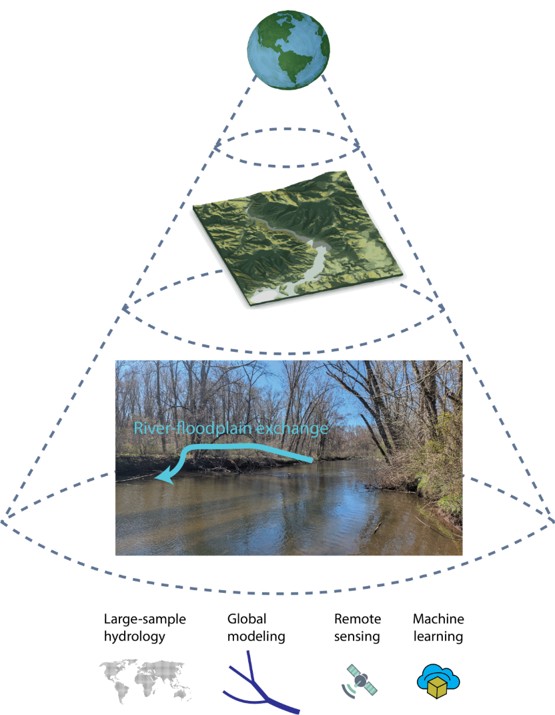
Fig. 1: A conceptual overview of the tools that this project will use to investigate river-floodplain exchange across spatial and temporal scales, from local to global. Photo is of the Quinnipiac River in the northeastern United States.
This project does not offer a CASE studentship
Each host has a slightly different application process.
Find out how to apply for this studentship.
All applications must include the CENTA application form.
Choose your application route
The project will expand the supervisory team’s United States model (and other related, ongoing analyses) and build a global machine learning model for river-floodplain exchange. This will involve the integration of existing river flow simulations, remotely sensed data (including the SWOT satellite), digital elevation models, machine learning methods, and large observational datasets covering all major river basins on Earth.
The student will compare simple machine learning tools to well-established global hydrodynamic flood simulations from collaborators. Such comparisons enable the student to use reduced-complexity methods to develop a conceptual framework of global river-floodplain exchange. They will use model outputs, large observational datasets, and expert and statistical classification schemes to determine distinct river-floodplain exchange regimes around the world. Statistical comparisons will be used to quantify how these regimes control downstream water quantity and quality using other global models.
They will also integrate with collaborator’s synergistic efforts to quantify anticipated changes to river-floodplain exchange under future climate conditions.
DRs will be awarded CENTA Training Credits (CTCs) for participation in CENTA-provided and ‘free choice’ external training. One CTC can be earned per 3 hours training, and DRs must accrue 100 CTCs across the three and a half years of their PhD.
The student will also gain advanced training in hydrology, biogeochemistry, hydro-informatics in Python/R environments, Earth observation, and environmental modelling. They will learn efficient ways to process, manage, and analyse large datasets as well as build reproducible computational pipelines for processing remotely sensed data, reanalysis datasets, and AI/ML outputs. Specific training will cover reproducible research methods, high-performance computing, uncertainty specification, scientific communication, and scientific writing/presentation. There will be a priority to attend relevant conferences to develop network and communication skills.
Through established international collaborations in river and hydrology research, the student will have extensive opportunity to engage with (and potentially visit) researchers working across river hydrodynamics, catchment science, and biogeochemistry, providing opportunities for research visits, conference participation, and collaborative publication.
Year 1: Where and when do floodplains matter? The student will adapt our United States model to global river basins. By integrating existing river flow simulations, digital elevation models, machine learning methods, and large observational datasets, the student will build a novel global characterisation of river-floodplain exchange across climate, topography, and disturbance gradients.
Year 2: What controls exchange? Leveraging year 1 data, the student will develop a framework explaining how runoff forcings, human flood management, and catchment characteristics manifest as different river-floodplain exchange regimes around the world. These regimes will be identified through both expert and statistical classification schemes, leveraging both model outputs and large observational datasets as complimentary approaches.
Year 3: How might exchange change in the future? Leveraging results from years 1 and 2, the student will characterize global shifts in river-floodplain exchange regimes given expected changes to flood regimes under climate change.
Brinkerhoff, C.B., Raymond, P.A. and Gleason, C.J., 2026. River‐floodplain exchange influences basin‐scale mixing during large fluvial flood events. Geophysical Research Letters, 53(10), p.e2026GL122190.
Brinkerhoff, C.B., 2024. The importance of source data in river network connectivity modeling: A review. Limnology and Oceanography, 69(12), pp.3033-3060.
Scott, D.T., Gomez-Velez, J.D., Jones, C.N. and Harvey, J.W., 2019. Floodplain inundation spectrum across the United States. Nature communications, 10(1), p.5194.
Wing, O.E., Bates, P.D., Quinn, N.D., Savage, J.T., Uhe, P.F., Cooper, A., Collings, T.P., Addor, N., Lord, N.S., Hatchard, S. and Hoch, J.M., 2024. A 30 m global flood inundation model for any climate scenario. Water Resources Research, 60(8), p.e2023WR036460.
Wohl, E., 2025. Conceptualizing river floodplains. Earth’s Future, 13(3), p.e2024EF005681.
For any enquiries related to this project please contact Craig Brinkerhoff, University of Birmingham, c.brinkerhoff@bham.ac.uk.
To apply to this project:
Applications must be submitted by 23:59 GMT on Wednesday 6th January 2027.