

Wildfire poses a growing threat to critical infrastructure, with consequences extending well beyond the burned area. Fires can damage electricity generation and transmission networks, disrupt rail and road systems and threaten data centres and drinking-water catchments. They also generate smoke severe enough to overburden hospitals with respiratory-related admissions and impair aerospace operations through poor visibility. Despite recent Birmingham-led progress on power network vulnerabilities to fire, there is no comprehensive, multi-sector global assessment of critical infrastructure exposure, nor evaluation of how exposure varies across infrastructure sectors or carries the greatest potential for disruption and wider socioeconomic impacts in different world regions.
This PhD will provide a systematic assessment of the global exposure of critical infrastructure to wildfire. It will combine satellite observations of individual fires from the Global Fire Atlas since 2002 with geospatial datasets mapping power network assets (including solar/wind generation sites), rail infrastructure, data centres, and drinking-water catchments. It will intersect modelled wildfire smoke concentrations (PM2.5) from ECMWF CAMS with population grids and respiratory morbidity curves to estimate unusual demand on hospitals. The same smoke models will be used to assess exceedance of critical visibility thresholds at airports. The project will quantify how frequently critical infrastructure is intersected by wildfire or critical smoke thresholds, identify geographical hotspots of exposure, and determine how exposure varies between infrastructure classes and fire regimes. This extends Birmingham’s recent work quantifying power network exposure to wildfire into a broader, cross-sector infrastructure exposure framework.
The project will connect wildfire exposure to socioeconomic consequences in the western USA and UK. Fire and smoke exposure will be linked through econometric analysis with parcel-, firm-, household- and area-level data to assess impacts on firm performance, employment, wages, house prices, migration, health and public finances, distinguishing direct damage from wider effects through smoke, risk, insurance and adaptation.
The research will establish a consistent framework for measuring wildfire exposure and impact across multiple infrastructure systems, identify where risk is concentrated, and quantify the economic significance of those risks. Its findings will be used by the State of Wildfires Project, landing with international audiences of policymakers, decision-makers, business leaders and media.
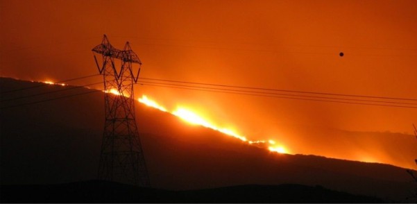
Figure 1: Power assets are critical infrastructure at risk of wildfire, as assessed in this project. Tim Williams, CC-BY-2.0.
This project is a CENTA Flagship Project.
This project offers a CASE studentship
Each host has a slightly different application process.
Find out how to apply for this studentship.
All applications must include the CENTA application form.
Choose your application route
The project will construct event-based wildfire exposure datasets using the Global Fire Atlas, which tracks individual fires and their behaviour from satellite observations since 2002. Fire events and behaviour metrics will be intersected with geospatial datasets for power networks, transport infrastructure, reservoir catchments, hospitals, data centres and airports. Direct exposures metrics include frequency, extent, recurrence and fire severity. ECMWF CAMS wildfire PM2.5 fields will be used to assess indirect smoke impacts. Combined with population exposure and respiratory morbidity relationships, they will quantify attributable hospital admissions and elevated healthcare demand; they will also be used to identify smoke and visibility thresholds relevant to airport operations. Exploratory statistical and machine-learning analyses, including explainable AI, will test which fire behaviour, environmental and infrastructure characteristics are associated with disproportionately high exposure or disruption. Regional US and UK econometric analyses will quantify socioeconomic impacts. Analyses will use Python/R and GIS-based geospatial workflows.
DRs will be awarded CENTA Training Credits (CTCs) for participation in CENTA-provided and ‘free choice’ external training. One CTC can be earned per 3 hours training, and DRs must accrue 100 CTCs across the three and a half years of their PhD.
With PI Matthew Jones, partners Douglas Kelley (UKCEH) and Chantelle Burton (Met Office) co-lead the State of Wildfires Project (https://stateofwildfires.com). The project publishes regular assessment reports on how extreme wildfire events impact society and the environment globally, and the extent to which those wildfires can be attributed to extreme weather, climate change, and socio-ecological factors like land use. Supported by Birmingham engineer Daniel Donaldson and economist Robert Elliott, and with CASE support from the S&P500 insurance company WTW (https://www.wtwco.com/en-gb/insights/research-programs-and-collaborations/willis-research-network), the student’s research will expand reporting of wildfire impacts and costs as part of the State of Wildfires Project.
Year 1: Training in required geospatial, statistical and programming methods; assemble and harmonise Global Fire Atlas, infrastructure and ECMWF CAMS datasets; develop reproducible Python/R/GIS workflows; construct global event-based exposure layers for all infrastructure sectors; initial analysis of geographical patterns of exposure and associated fire properties.
Year 2: Extend analyses to indirect smoke impacts, quantifying wildfire-attributable hospital admissions and smoke/visibility hazards affecting airport operations; compare exposure across infrastructure classes and fire regimes; undertake exploratory statistical, machine-learning and explainable AI analyses to identify environmental, fire-behaviour and infrastructure characteristics associated with disproportionately high exposure or disruption; prepare first publications.
Year 3: Develop western USA and UK econometric case studies linking fire and smoke exposure to socioeconomic outcomes using spatial panel data, event-study and difference-in-differences designs; examine heterogeneous effects across firms, labour markets, housing, health and public finances; integrate findings across infrastructure sectors; publish results through peer-reviewed papers and the State of Wildfires Project; complete thesis synthesis and submission.
Publications relevant to the project
Bunting, R., Donaldson, D., Little, K. and Kettridge, N. (2026) ‘Global exposure of electrical transmission and distribution networks to landscape fires reveals stark geographic inequality’. Research Square. Available at: https://doi.org/10.21203/rs.3.rs-10592463/v1.
Dossi, S., Donaldson, D.L., Little, K. and Pastor, E. (2026) ‘Wildfire risk to critical infrastructure: A systematic review highlighting the need for cross-sector collaboration’, Climate Risk Management, 52, p. 100818. Available at: https://doi.org/10.1016/j.crm.2026.100818.
Jones, M.W., Abatzoglou, J.T., Veraverbeke, S., Andela, N., Lasslop, G., Forkel, M., Smith, A.J.P., Burton, C., Betts, R.A., Van Der Werf, G.R., Sitch, S., Canadell, J.G., Santín, C., Kolden, C., Doerr, S.H. and Le Quéré, C. (2022) ‘Global and Regional Trends and Drivers of Fire Under Climate Change’, Reviews of Geophysics, 60(3), p. e2020RG000726. Available at: https://doi.org/10.1029/2020RG000726.
Jones, M.W., Abatzoglou, J.T., Burton, C., Fernandes, P.M., Jain, P., Keeping, T., Tanpipat, V. and Kolden, C.A. (2026) ‘Wildfires in 2025’, Nature Reviews Earth & Environment, 7(6), pp. 334–336. Available at: https://doi.org/10.1038/s43017-026-00793-z.
Kelley, D.I., Burton, C., Di Giuseppe, F., Jones, M.W., Barbosa, M.L.F., Brambleby, E., McNorton, J.R., Liu, Z., Bradley, A.S.I., Blackford, K., Burke, E., Ciavarella, A., Di Tomaso, E., Eden, J., Ferreira, I.J.M., Fiedler, L., Hartley, A.J., Keeping, T.R., Lampe, S., Lombardi, A., Mataveli, G., Qu, Y., Silva, P.S., Spuler, F.R., Steinmann, C.B., Torres-Vázquez, M.Á., Veiga, R., Van Wees, D., Wessel, J.B., Wright, E., Bilbao, B., Bourbonnais, M., Gao, C., Di Bella, C.M., Dintwe, K., Donovan, V.M., Harris, S., Kukavskaya, E.A., N’Dri, A.B., Santín, C., Selaya, G., Sjöström, J., Abatzoglou, J.T., Andela, N., Carmenta, R., Chuvieco, E., Giglio, L., Hamilton, D.S., Hantson, S., Meier, S., Parrington, M., Sadegh, M., San-Miguel-Ayanz, J., Sedano, F., Turco, M., Van Der Werf, G.R., Veraverbeke, S., Anderson, L.O., Clarke, H., Fernandes, P.M. and Kolden, C.A. (2025) ‘State of Wildfires 2024–2025’, Earth System Science Data, 17(10), pp. 5377–5488. Available at: https://doi.org/10.5194/essd-17-5377-2025.
Meier, S., Elliott, R.J.R. and Strobl, E. (2023) ‘The regional economic impact of wildfires: Evidence from Southern Europe’, Journal of Environmental Economics and Management, 118, p. 102787. Available at: https://doi.org/10.1016/j.jeem.2023.102787.
Wang, D., Guan, D., Zhu, S., Kinnon, M.M., Geng, G., Zhang, Q., Zheng, H., Lei, T., Shao, S., Gong, P. and Davis, S.J. (2021) ‘Economic footprint of California wildfires in 2018’, Nature Sustainability, 4(3), pp. 252–260. Available at: https://doi.org/10.1038/s41893-020-00646-7.
Datasets and tools available to the project:
Andela, N., Morton, D.C., Giglio, L., Paugam, R., Chen, Y. and Hantson, S. (2019) ‘The Global Fire Atlas of individual fire size, duration, speed and direction’, Earth System Science Data, 11(2), pp. 529–552. Available at: https://doi.org/10.5194/essd-11-529-2019.
ArcGIS Online (2026) World Airports. Available at: https://hub.arcgis.com/datasets/esri-de-content::world-airports (Accessed: 8 September 2026).
ECMWF (2026) New ‘Fire Emissions Watch’ tool provides instant access to global fire emissions data. Available at: https://atmosphere.copernicus.eu/copernicus-new-fire-emissions-watch-tool-provides-instant-access-global-fire-emissions-data (Accessed: 8 September 2026).
Global Data Center Map (2026) Global Data Center Map. Available at: https://github.com/ringmast4r/Global-Data-Center-Map (Accessed: 8 September 2026).
Global Healthsites Mapping Project (2026) Global Healthsites Mapping Project. Available at: https://wiki.openstreetmap.org/wiki/Global_Healthsites_Mapping_Project (Accessed: 8 September 2026).
NASA EarthData (2026) Global Reservoir and Dam Database, Version 1 (GRanDv1). Available at: https://www.earthdata.nasa.gov/data/catalog/sedac-ciesin-sedac-grandv1-dams-1.01 (Accessed: 8 September 2026).
OpenInfrastructureMap (2026) Open Infrastructure Map. Available at: https://openinframap.org/ (Accessed: 8 September 2026).
WorldPop (2026) Open Spatial Demographic Data and Research. Available at: https://www.worldpop.org/ (Accessed: 8 September 2026).
Useful links:
For any enquiries related to this project please contact Matthew William Jones, [email protected]
To apply to this project:
Applications must be submitted by 23:59 GMT on Wednesday 6th January 2027.