

Acid sulfate soils contain sulfide minerals that can generate sulfuric acid when exposed to oxygen through drainage, excavation or drought. Subsequent rewetting can mobilise accumulated acidity and metals into surrounding waters, threatening ecosystems and complicating agricultural management and wetland restoration. Recognising these soils before disturbance is therefore essential. However, knowing where they occur does not necessarily reveal how their hazards will be expressed following management change.
This PhD will establish how reliably legacy soil information predicts acid sulfate soil occurrence, and whether incorporating land-management history improves prediction of acidification responses across contrasting UK landscapes. It will test whether combining historical evidence with soil and environmental properties improves prediction beyond existing classifications, and whether drainage and rewetting histories explain responses that soil properties alone cannot resolve.
First, the project will integrate soil classifications, historical descriptions and information accessed through Cranfield’s LandIS Soils Data Portal with geological, terrain and hydrological maps, analyses of archived samples and fresh, depth-resolved field observations. This will identify useful predictors while evaluating how sampling depth, classification and sample preservation affect recognition.
Second, these findings will inform a predictive mapping framework, validated in spatially independent study areas. Comparing models built from different combinations of evidence will establish which indicators transfer across contrasting landscapes, where predictions fail and what additional information improves their reliability.
Third, the project will distinguish persistent indicators of acid sulfate soil occurrence from evidence that changes following drainage, disturbance or rewetting. Existing soil profile records, management histories and relevant site data from UKCEH’s Lowland Peat research sites, including Pymoor, will be combined with new observations from agricultural and coastal restoration settings. Comparisons among environmentally similar sites will test whether management obscures, preserves or reveals diagnostic signals, and whether management information helps explain observed acidification.
The project will deliver an independently tested mapping framework and practical guidance for investigating and managing acid sulfate soil hazards. UKCEH will provide co-supervision, access to established research sites and relevant existing data. GTK (Finland) will act as the formal CASE partner, coordinating placements up to three months to develop field, laboratory and predictive-mapping skills.
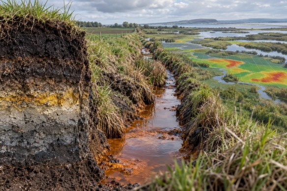
Figure 1: Conceptual soil profile and orange drainage channel beside a wetland overlaid with a predictive risk map.
This project is a CENTA Flagship Project.
This project offers a CASE studentship
Each host has a slightly different application process.
Find out how to apply for this studentship.
All applications must include the CENTA application form.
Choose your application route
Objective 1: Soil classifications, profile descriptions and environmental datasets accessed through the LandIS Soils Data Portal will be combined with geological, terrain and hydrological maps. Fresh profiles will be described and sampled by horizon to compare diagnostic evidence, including low pH and sulfur-related features, with historical records.
Objective 2: Statistical and machine learning models will estimate the probability of acid sulfate soil occurrence and be benchmarked against existing classifications. Stratified field sampling across contrasting landscapes and predicted occurrence classes will provide spatially independent validation, quantifying accuracy, missed occurrences and uncertainty.
Objective 3: At selected agricultural and coastal restoration sites, field observations will be integrated with management histories, existing datasets and UKCEH soil profile records. Pymoor will provide a focal case study, with comparisons among environmentally similar sites assessing whether drainage, disturbance and rewetting obscure, preserve or reveal predictive signals, and whether management information improves model performance.
DRs will be awarded CENTA Training Credits (CTCs) for participation in CENTA-provided and ‘free choice’ external training. One CTC can be earned per 3 hours training, and DRs must accrue 100 CTCs across the three and a half years of their PhD.
The researcher will develop skills in soil description, classification, diagnostic sampling, GIS, predictive modelling and uncertainty assessment. Cranfield will train them to interpret legacy records and use the LandIS Soils Data Portal. One or more CASE placements with GTK, totalling at least three months, will develop expertise in acid sulfate soil identification and predictive mapping. Adelaide’s Acid Sulfate Soils Centre will support interpretation of morphological and chemical indicators. UKCEH will provide training through research sites, datasets and expertise in drainage and rewetting. Engagement with managers and agencies will develop interpretation and communication skills. An initial training-needs assessment will guide development.
UKCEH will contribute co-supervision, access to Defra Lowland Peat research sites, including Pymoor, and soil profile and existing data. GTK (Finland) will act as the CASE partner. Anton Boman will co-supervise and coordinate one or more placements totalling at least three months, providing training in acid sulfate soil diagnosis and predictive mapping. Green Shores will advise on coastal restoration settings, help identify sites and support translation of findings for practitioners. Adelaide’s Acid Sulfate Soils Centre will provide specialist guidance on diagnostic field and laboratory indicators and interpretation of management responses.
Year 1: Complete the literature review on soil classification, predictive soil mapping, soil-landscape relationships and the effects of agricultural management and coastal restoration on soil properties. Compile and evaluate soil classifications, historical records and environmental datasets through the LandIS Soils Data Portal. Undertake the planned three-month GTK placement to develop diagnostic and predictive mapping skills. Conduct initial field sampling, identify candidate predictors and establish the modelling approach (Objective 1).
Year 2: Develop the predictive framework and undertake stratified field sampling for independent validation across contrasting landscapes (Objective 2). Collect management histories alongside field observations, selecting agricultural and coastal restoration case studies with comparable environmental settings (Objective 3). Attend one relevant UK-based conference (e.g. BSSS Annual Conference) to present emerging findings, receive feedback and build connections with researchers and practitioners.
Year 3: Complete validation and assess how drainage, disturbance and rewetting histories overprint predictive signals. Test whether incorporating management information improves predictions, refine the framework and identify its limitations (Objectives 2-3). Develop a practical toolkit translating the predictive framework into guidance, workflows and resources for land managers and restoration practitioners, in collaboration with participating partners. Attend one relevant international conference (EGU General Assembly) to present findings and enrich interdisciplinary connections.
Final six months: Integrate findings, finalise the thesis and submit. Complete documentation and archiving of datasets, maps and reproducible analytical workflows, and communicate findings to research and practitioner audiences.
Estévez, V., Beucher, A., Mattbäck, S., Boman, A., Auri, J., Björk, K.M. and Österholm, P. (2022) ‘Machine learning techniques for acid sulfate soil mapping in southeastern Finland’, Geoderma, 406, article 115446. doi: 10.1016/j.geoderma.2021.115446.
Fanning, D.S., Rabenhorst, M.C. and Fitzpatrick, R.W. (2017) ‘Historical developments in the understanding of acid sulfate soils’, Geoderma, 308, pp. 191–206. doi: 10.1016/j.geoderma.2017.07.006.
Grealish, G.J., Fitzpatrick, R.W. and Shand, P. (2014) ‘Regional distribution trends and properties of acid sulfate soils during severe drought in wetlands along the lower River Murray, South Australia: Supporting hazard assessment’, Geoderma Regional, 2–3, pp. 60–71. doi: 10.1016/j.geodrs.2014.10.003.
Rabenhorst, M.C., Fitzpatrick, R. and Boman, A. (2025) ‘The evolving classification of acid sulfate soils’, European Journal of Soil Science, 76(1), article e70057. doi: 10.1111/ejss.70057.
For informal project enquiries, please contact Dr Dan Evans, Senior Lecturer in Soil Science, Cranfield University: [email protected].
Further information about the supervisor’s research is available on his Cranfield University profile.
To apply to this project:
Applications must be submitted by 23:59 GMT on Wednesday 6th January 2027.