

Research Question: What lies beneath and within Dartmoor’s earliest peat, how did it form and when?
Context: Dartmoor’s blanket peat seals and preserves poorly understood prehistoric land surfaces comprising buried soils, occupation horizons and archaeologically rich deposits that predate/are contemporaneous with peat growth. At Cut Hill, Bray leads ongoing interdisciplinary research which offers a rare high-profile example: a radiocarbon-dated sequence associated with Neolithic and Bronze Age archaeology, demonstrating both the survival of such surfaces within and beneath the peat, and value of characterising them before they are lost (Fyfe and Greaves 2010; DNPA 2024). Elsewhere on Dartmoor, geoarchaeological work has shown that soil erosion and land surface change began before, and continued after, the construction of Bronze Age monuments (Balaam et al. 1982; Carey et al. 2024), yet the degree of anthropogenic influence on such processes, and the relationships between buried land surfaces mapped thus far, remains debated.
Why now? More than 800 hectares of Dartmoor’s peat are being re-wetted and reprofiled for restoration offering geoarchaeological analysis opportunities. Buried prehistoric surfaces are rarely characterised or independently dated before work proceeds. Although sub-peat material is not destroyed, reprofiling removes unstable peat faces and ultimately buries the erosion-cut exposures that first revealed these surfaces. The project will generate evidence to support both natural and cultural heritage management practices and help us understand long-term human-landscape dynamics.
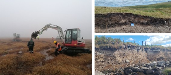
Approach: Building on pilot fieldwork showing that portable luminescence readers can be used to rapidly screen sediment for its light exposure history (Fig 1), the doctoral researcher (DR) will develop and test methods for field-based characterization and relative dating of buried prehistoric surfaces. Each method will be recorded using traditional geoarchaeological methods, (sedimentology stratigraphy and topography) supplemented by radiocarbon dating and an additional proxy suited to the DR’s own expertise (e.g. micromorphology, palynology, geochemistry)
Wider applicability: Equivalent buried surfaces occur beneath peat and shallow soils across the UK’s other upland moors and under comparable European mountain and blanket bog landscapes. The methodology developed here is designed to travel beyond Dartmoor offering a rapid low-cost approach to a problem shared by upland archaeology and peatland restoration internationally.
Figure 1: Peat Restoration works in progress & examples of sections underlying Dartmoor Peat suitable for sampling 2026 (Images© DNPA).
This project does not offer a CASE studentship
Each host has a slightly different application process.
Find out how to apply for this studentship.
All applications must include the CENTA application form.
Choose your application route
The doctoral researcher will begin with a desk-based review of the Historic Environment Record and paleoenvironmental literature on early peat formation and the preceding periods. A GIS-informed walkover survey drawing on DNPA knowledge will map exposures where buried surfaces are visible; where none exist cores or test pits will be used. At each site, stratigraphy, sedimentology and topographic context will be recorded using geomatic and geoarchaeological methods, and sediment screened in the field using a portable OSL/IRSL reader to build relative dating chronologies within and between exposures. Selected samples will be dated by OSL/IRSL dating methods at Leicester, with radiocarbon dating of organics providing independent age control where required. The DR will also add an analytical strand to suited to their expertise e.g. micromorphology palynology biomarkers or geochemistry) to evaluate environmental/anthropogenic influences during periods of land surface occupation, testing transferability to comparable upland peaks elsewhere in the Europe and UK.
DRs will be awarded CENTA Training Credits (CTCs) for participation in CENTA-provided and ‘free choice’ external training. One CTC can be earned per 3 hours training, and DRs must accrue 100 CTCs across the three and a half years of their PhD.
The supervisory team offers complementary expertise: Basell will provide training in geoarchaeological and geomatics methods (geomatic survey, geospatial analyses, stratigraphic recording, sampling, and site description). Carr and Basell will provide training in sedimentology and geomorphological interpretation. Carr will train the DR in portable and laboratory luminescence sample preparation and analysis in the Leicester Luminescence Dating Facility. Further training in the DRs chosen second proxy will be arranged with Leicester specialists or external laboratories. Partners: Bray and DNPA will provide training in Historic Environment Record use, fieldwork practice, community engagement and landscape management policy. ORAU offers radiocarbon dating support.
Dartmoor National Park Authority (DNPA) provides site access, Historic Environment Record data, archaeological and logistics support, building on Bray’s (Head of Cultural Heritage) established co-supervision of PhDs with Basell, and active research the Dartmoor Tor Enclosures Project, Cut Hill Cist and buried surfaces (Carey et al. 2024). The Oxford Radiocarbon Accelerator Unit will support high-precision dating of buried organic horizons, providing independent chronological control. The South West Peatland Partnership offers co-ordinated access to restoration sites and prioritised exposures moor-wide, while the Dartmoor Headwaters Project (via Bray) provides an existing monitoring framework and baseline data into which findings can feed directly.
Year 1: Literature review and historic environment record review; with partners, LiDAR and walkover survey to identify candidate exposures and test pit or core locations; training in portable luminescence screening, geomatics and sedimentology and, if required supplementary training in student’s chosen palaeoecological proxy/proxies; visit to ORAU to enhance knowledge about radiocarbon methods; submit NEIF application; begin literature review and method chapter drafts. Present project at a regional conference in SW England via talk or poster.
Year 2: Complete outstanding fieldwork recording and sampling; submission (radiocarbon) and analyses of samples. Complete luminescence analyses in field and in laboratory (where required), and analyses of second proxy method, sedimentology and topography results; develop modelling skills. Draft Results and Discussion chapters; National conference presentation or 1st paper drafted.
Year 3: Review policy documentation. Synthesise/model the chronology and character on buried prehistoric surfaces across all sites. Assess transferability of the methodology to other UK European uplands. Write Introduction and concluding chapter and review all draft chapters. Present findings and management recommendations to DNPA and SW peatland partnership and present results at an international conference. Final months for the thesis submission and viva preparation
Balaam, N.D., Smith, K. and Wainwright, G.J. (1982) ‘The Shaugh Moor project: fourth report -environment, context and conclusions’, Proceedings of the Prehistoric Society, 48, pp. 203–278.
Carey, C., Hunnisett, K., Macphail, R., Bray, L., Toms, P., Wood, J. and Crabb, A. (2024) ‘What happened before the Middle Bronze Age land divisions and roundhouses? Prehistoric soil erosion and landscape change on Dartmoor, UK’, Journal of Archaeological Science: Reports, 56, 104506.
Fyfe, R. and Greeves, T. (2010) ‘The date and context of a stone row: Cut Hill, Dartmoor, south-west England’, Antiquity, 84(323), pp. 55–70.
Dartmoor National Park Authority (2024) Cut Hill burial cist. Available at: https://www.dartmoor.gov.uk/wildlife-and-heritage/heritage/bronze-age/cut-hill-burial-cist (Accessed: 11 September 2026). [Page last updated 19 August 2024.]
For any enquiries related to this project please contact Dr Laura Basell, [email protected].
To apply to this project:
Applications must be submitted by 23:59 GMT on Wednesday 6th January 2027.