

Land surface temperature (LST) describes how hot the surface would feel to the touch. This data has been central to understanding how energy moves around the planet, from unveiling ocean currents to quantifying how elevated temperatures over cities endanger residents. Suspended above this are aerosols, tiny particles or droplets such as smoke or sulphuric acid. While some occur naturally, long-term exposure to excessive aerosol levels is a major driver of childhood mortality and long-term illness. Aerosols also act as the seed from which most cloud droplets form. As clouds block the flow of light and heat through the atmosphere, when human-driven changes in aerosol change the clouds that form we also change where heat is stored. A shift in cloud brightness of 5% would theoretically completely counteract the energy trapped by carbon dioxide. These aerosol-cloud interactions have repeatedly been identified as the most uncertain feedback within the climate system, aggravated by the lack of reliable, representative data to constrain our conceptual models.
Surface temperature, aerosols, and clouds are all observed using thermal radiation such that their measurements are interdependent, but they are traditionally measured separately. Cloud or haze masks a satellite’s view of the surface while their shadows cool surface temperatures. This “clear-sky bias” is an inherent limitation of climate data as we lose our greatest source of information at the lowest temperatures, limiting our ability to test climate models. Additionally, there is substantial uncertainty about the changing distribution of high, thin cirrus clouds as a reliable surface temperature is required to accurately locate the cloud.
This doctoral research project proposes to combine the University of Leicester’s world-leading retrievals of land-surface temperature, aerosol, and cloud into a single, synergistic product that will provide the first self-consistent view of the atmosphere and surface simultaneously. A successful applicant will join the LST Group and the Optimal Retrieval of Aerosol and Cloud (ORAC) project ̶ international teams of measurement experts who provide data to the European Space Agency and Copernicus Climate Change Service. Applicants should have a background in a quantitative physical science like physics, mathematics, or geography.
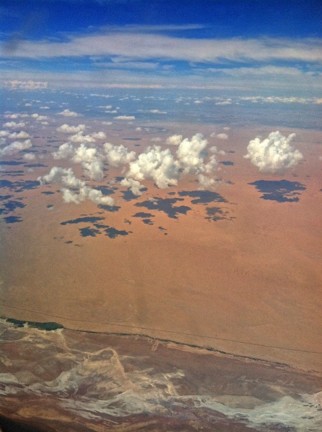
Figure 1: Shadowing by clouds and aerosols biases surface temperature measurements as they can only observe the clear-sky areas despite shadows reducing temperatures. “Cloud shadows from 34k feet” by Kirt Edblom is licensed under CC BY-SA 2.0.
This project does not offer a CASE studentship
Each host has a slightly different application process.
Find out how to apply for this studentship.
All applications must include the CENTA application form.
Choose your application route
Research will initially adapt the ORAC algorithm to simultaneously retrieve aerosol/cloud and surface temperature. You will develop computing skills by integrating previous work over sea into the code base, learning scientific programming practices. That framework will be extended to land by implementing the LST group’s expertise in surface emissivity estimation, quantifying the uncertainty in the new inputs. The software will be validated against ground-based and orbital platforms to demonstrate accuracy and fitness for purpose.
The project will then run novel, simultaneous retrievals to quantify the climatology of clear-sky bias in surface temperature over Europe (where the emissivity database is available). The final stages will be guided by the interests of the student, looking at currently unmeasured areas (e.g. coastlines) to address outstanding scientific questions such as how the variability and trends of temperature and cirrus cloud changes across the land-sea transition.
DRs will be awarded CENTA Training Credits (CTCs) for participation in CENTA-provided and ‘free choice’ external training. One CTC can be earned per 3 hours training, and DRs must accrue 100 CTCs across the three and a half years of their PhD.
Statistical analysis will be learned practically through scientific study of environmental data. Field work to collect additional ground observations as part of the LST group’s validation network could be explored. Experience with scientific coding will be developed through collaborative working and courses on Python and Fortran available through CENTA. Leicester will provide instruction in optimisation methods and radiative transfer. Presentation and communication skills are taught at the Doctoral College, which will be refined at meetings of our lab, the ORAC project, NCEO research themes, and (inter)national conferences.
Year 1: Learn optimal estimation by implementing previous algorithm changes within new code base; Build familiarity with environmental data by evaluating results against validation sites; Refine statistical knowledge by compiling prior uncertainty in surface emissivity
Year 2: Implement surface emissivity model within ORAC; Process joint aerosol/cloud-LST data over the UK; Validate; Quantify clear-sky bias in previous data
Year 3: Assess statistics of clear-sky bias over the UK in aerosol and LST data; Process data around coasts to assess sensitivity of cirrus cloud to the land-sea transition
Fan, J., Y. Wang, D. Rosenfeld, and X. Liu (2016) ‘Review of Aerosol–Cloud Interactions: Mechanisms, Significance, and Challenges’, Journal of the Atmospheric Sciences, 73, pp. 4221–4252, doi:10.1175/JAS-D-16-0037.1.
Langsdale, Mary, Tijl Verhoelst, Adam Povey, Nick Schutgens, Thomas Dowling, Jean-Christopher Lambert, Steven Compernolle, and Stefan Kern, ‘The Challenges and Limitations of Validating Satellite-Derived Datasets Using Independent Measurements: Lessons Learned from Essential Climate Variables’, Surveys in Geophysics, 2025, doi: https://dx.doi.org/10.1007/s10712-025-09898-4
Sus, O., Stengel, M., Stapelberg, S., McGarragh, G., Poulsen, C., Povey, A. C., Schlundt, C., Thomas, G., Christensen, M., Proud, S., Jerg, M., Grainger, R., and Hollmann, R. (2018) ‘The Community Cloud retrieval for CLimate (CC4CL) – Part 1: A framework applied to multiple satellite imaging sensors’, Atmospheric Measurement Techniques, 11, pp. 3373–3396, doi:10.5194/amt-11-3373-2018.
McGarragh, G. R., Poulsen, C. A., Thomas, G. E., Povey, A. C., Sus, O., Stapelberg, S., Schlundt, C., Proud, S., Christensen, M. W., Stengel, M., Hollmann, R., and Grainger, R. G. (2018) ‘The Community Cloud retrieval for CLimate (CC4CL) – Part 2: The optimal estimation approach’, Atmospheric Measurement Techniques, 11, pp. 3397–3431, doi:10.5194/amt-11-3397-2018.
For any enquiries related to this project please contact De Adam Povey, [email protected].
The ORAC community code base: https://github.com/ORAC-CC/orac
Dr Povey’s personal website: https://le.ac.uk/people/adam-povey
Weather and Climate Research Lab: https://www.wcrl.co.uk/
Earth Observation Science at Leicester: https://le.ac.uk/physics/research/earth-observation-science
To apply to this project:
Applications must be submitted by 23:59 GMT on Wednesday 6th January 2027.