

Vegetation stress caused by drought, heatwaves, soil moisture deficits and disease is becoming an increasingly important environmental and societal challenge. Stress often manifests through changes in plant temperature before visible symptoms appear, making land surface temperature (LST) a powerful indicator of vegetation condition. Thermal observations provide direct information on plant energy balance and transpiration, while optical measurements offer complementary information on canopy structure, chlorophyll content and vegetation vigour.
Current commercial monitoring solutions are often expensive, limiting their deployment across agricultural landscapes, ecological observatories and citizen science networks. Advances in low-cost thermal radiometry, multispectral imaging and embedded computing now create opportunities for cost-effective monitoring stations that can operate autonomously and support both local decision-making and satellite validation activities.
Recent and forthcoming thermal infrared satellite missions, including the European Space Agency’s Land Surface Temperature Monitoring (LSTM) mission and the CNES/ISRO Thermal Infrared Imaging Satellite for High-resolution Natural Resource Assessment (TRISHNA), are expected to transform environmental monitoring by delivering unprecedented observations of land surface temperature at high spatial resolution. However, the successful exploitation of these observations requires reliable ground-based measurements capable of capturing vegetation dynamics at high temporal frequency and linking field-scale processes with satellite observations.
This PhD project will develop an integrated low-cost in-situ vegetation monitoring station combining thermal radiometry and optical imaging to detect vegetation stress and provide a bridge between in-situ observations and satellite products. The project will investigate how thermal and optical measurements can be combined to identify early stress signals and how information from the ground station can be scaled and transferred to current and future satellite missions.
This PhD will demonstrate an innovative and fully characterised thermal-optical monitoring tools to detect vegetation stress caused by heatwaves and drought. The project will deliver a low-cost monitoring station, new insights into vegetation temperature measurements, advanced stress-detection techniques, and a framework linking field observations with next-generation thermal satellite missions (LSTM and TRISHNA). By combining ground and satellite data, it will demonstrate an early warning system to support climate-resilient agriculture, improve drought monitoring, and enhance decision-making for farmers, researchers, and the Earth observation community.
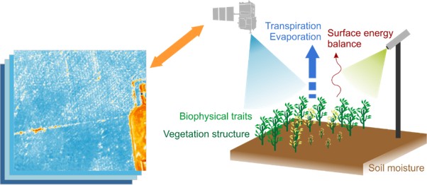
Figure 1:From in-situ vegetation monitoring to the satellite operational uptake. In-situ stations help develop a baseline for vegetation reactions to heat stress that can be used to calibrate and validate satellite image products. Source: own work.
This project does not offer a CASE studentship
Each host has a slightly different application process.
Find out how to apply for this studentship.
All applications must include the CENTA application form.
Choose your application route
The methodology will initially focus on designing of an autonomous monitoring system for continuous vegetation stress detection. This will comprise of laboratory testing and calibration and the eventual field deployment of: 1) Thermal-infrared radiometers measuring upwelling and downwelling radiation, and 2) A low-cost multispectral optical camera optimised for vegetation monitoring.
As this project investigates combining thermal and optical measurements for plant stress detection before visible deterioration occurs, you will:
DRs will be awarded CENTA Training Credits (CTCs) for participation in CENTA-provided and ‘free choice’ external training. One CTC can be earned per 3 hours training, and DRs must accrue 100 CTCs across the three and a half years of their PhD.
The candidate will work with the science team lead for the future ESA LSTM mission, part of the Earth Observation Science group based at Space Park Leicester.
The student will develop computational expertise in satellite data processing and coding/programming skills in Python whilst working on the High-Performance Computing Linux environment.
The student will learn how to work in a professional experimental laboratory and receive instrumentation calibration/validation training and learn how to plan and execute fieldwork and experiments.
Finally, the student will be trained in scientific communication (presentation to scientists and general public, report and scientific writing).
Year 1 will establish project foundations through a review of state-of-the-art vegetation monitoring methods, evaluation of low-cost thermal-optical stations for vegetation stress detection, assess the benefits of combining thermal and multispectral observations, and develop methodologies supporting operational early warning systems.
Year 2 will refine and finalise the approach by identifying optical measurements for surface emissivity estimation to improve in-situ land surface temperature retrievals and determine reliable time-series indicators of vegetation stress.
Year 3 will assess the transferability of station-derived indicators to LSTM and TRISHNA satellite observations and quantify the impacts of observation geometry and directional effects on vegetation temperature and stress detection.
Journal:
Dash, S. K., Sembhi, H., & Sinha, R., 2026. Integrating UAV thermal imagery and in-situ data for high-resolution crop water stress–soil moisture dynamics over India’s agricultural hotspot. International Journal of Remote Sensing, 47(1), 1–26. https://doi.org/10.1080/01431161.2025.2593684
Lausch, A., Bastian, O., Klotz, S., Leitão, P.J., Jung, A., Rocchini, D., Schaepman, M.E., Skidmore, A.K., Tischendorf, L. and Knapp, S., 2018. Understanding and assessing vegetation health by in situ species and remote‐sensing approaches. Methods in ecology and evolution, 9(8), pp.1799-1809. https://doi.org/10.1111/2041-210X.13025
Göttsche, F.M., Olesen, F.S., Trigo, I.F., Bork-Unkelbach, A. and Martin, M.A., 2016. Long term validation of land surface temperature retrieved from MSG/SEVIRI with continuous in-situ measurements in Africa. Remote Sensing, 8(5), p.410. https://doi.org/10.3390/rs8050410
Web page with an author:
Spengler, D., Schmidt, R., Soszynska, A. Revolutionizing Agriculture through Thermal Satellite Insights https://thermal-rs.earsel.org/?page_id=632
Siggs, Ch. Interviewed in the Thermal Lens, Those Space People podcast “Monitoring Plant Health from Space” https://thermal-rs.earsel.org/?page_id=669
Langsdale, M., interviewed in the Thermal Lens, Those Space People podcast “The impact of directionality on Land Surface Temperature” https://thermal-rs.earsel.org/?page_id=692
Web page with an institutional author:
Special Interest Group on Thermal Remote Sensing, slides and recordings from a workshop in 2024, including various videos e.g., Introduction to retrieving surface temperature, future missions LSTM and TRISHNA, Evapotranspiration using TIR data https://thermal-rs.earsel.org/?page_id=1122
Interested candidates are encouraged to contact Dr Harjinder Sembhi ([email protected]), Dr Darren Ghent ([email protected]) or Dr Agnieszka Soszynska ([email protected]) to discuss the project before applying.
To apply to this project:
Applications must be submitted by 23:59 GMT on Wednesday 6th January 2027.