

From storm Desmond (2015) to the Dudley-Eunice-Fraklin sequence (2022) extratropical cyclones inflict extreme winds upon the UK and Northwest Europe resulting in multi-sector impacts (e.g. road, power distribution) and billions of pounds in insured losses (Kendon, 2022; Saville, 2022). This project in the cutting-edge field of visual anemometry (e.g., Kulkarni, 2026) will help to solve the real-world challenge of assessing wind risk in complex urban environments by extracting gust wind speeds from short video clips (e.g. of trees). You will have the opportunity to conduct an exciting blend of sensor deployment, physical modelling and image analysis.
Peak 3-second gusts (s₃) during severe storms drive wind damage, yet how they vary over short distances in complex (e.g. urban) environments is very difficult to capture. Traditional instrumentation (e.g. weather stations, Doppler LiDAR) is expensive, and observational data (e.g. ERA5) have a resolution of 10s of km. Visual anemometry – wind speed from videos – is a likely solution. Whilst work has been done using machine learning and/or physically-based models (e.g., Cardona, 2021; Zhang, 2022), ours is the first to use optical flow to estimate s₃ – which meteorologists use (Kulkarni, 2026) and shows great potential.
Our hypotheses that you will refine and test are:
Our pilot work has established methods and code to extract s₃ from a few selected trees (Kulkarni, 2026). Great opportunities exist to jump forwards from this; (i) systematic, long term data collection in a ‘living lab’, (ii) linking these ultra-high resolution observations to traditional weather forecasts and data (e.g. ERA5), and (iii) ‘digital twin’ experiments. Ultimately, the improved wind distribution mapping could go national (e.g. with the UK’s road network CCTV cameras) as well as detailed site hazard assessments for the (re)insurance sector.
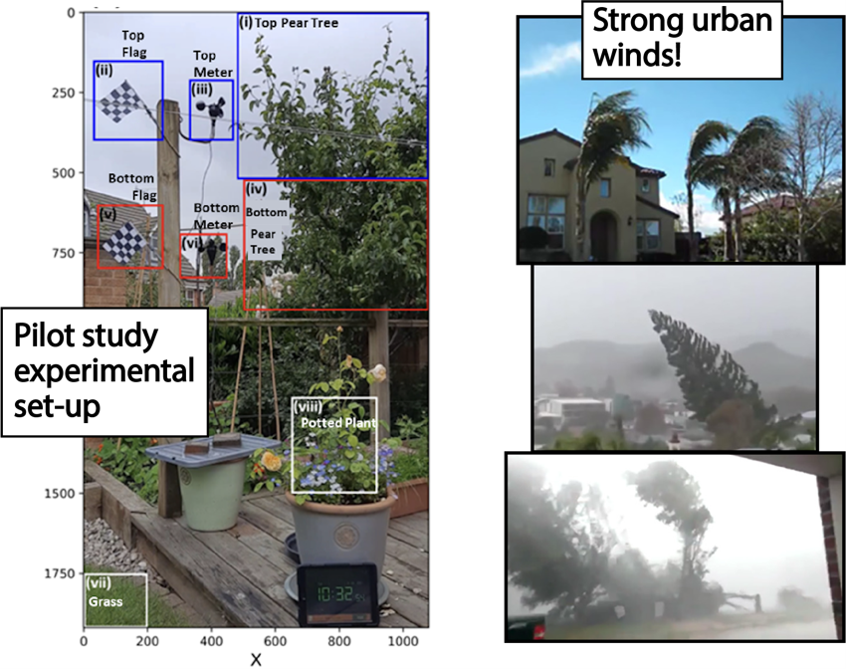
Figure 1: Left) Pilot experimental set-up for visual anemometry in a domestic setting using a handheld camera (Kulkarni et al., 2026), which this PhD will surpass with multiple specifically designed and long-term installations on the university campus. Right) Illustrations of tree movement in very windy conditions (Zhang et al., 2022).
This project does not offer a CASE studentship
Each host has a slightly different application process.
Find out how to apply for this studentship.
All applications must include the CENTA application form.
Choose your application route
This PhD will be based around a ‘living lab’ campus-scale study, linked to the university’s weather station, but underpinned by the installation of at least 4-5 sets of sensors (i.e. camera, data logger, anemometer, flag, tree, wind vane) to do a quasi-continuous long-term study (i.e. ³ 12 months). This will provide the large datasets required for machine learning approaches to be applied and be supplemented by laser scanning an ad hoc videos (e.g. mobile phone to capture multiple viewing angles). Visual anemometry will initially use OFTV (FlowOnTheGo), augmented by machine learning and image analysis as appropriate. An existing digital twin that incorporates the physics of tree deformation will be used for complementary exploration of ideas in controlled and/or very extreme conditions. To make the link to wider-scale atmospheric conditions, reanalysis products such as ERA5 will be used.
DRs will be awarded CENTA Training Credits (CTCs) for participation in CENTA-provided and ‘free choice’ external training. One CTC can be earned per 3 hours training, and DRs must accrue 100 CTCs across the three and a half years of their PhD.
The successful PhD candidate will receive training in applying machine learning (e.g. to image processing) and the computer skills to run specific analytical and machine vision software (e.g. Flow on the Go, ParaView) and more generic coding as required (e.g. R and/or python). In addition to this, training will be given in relevant applied meteorology (e.g., Hillier et al., 2025) and the field work skills required (e.g. laser scanning, camera and anemometer installation).
This PhD is complementary to and will collaborate with Prof. Theresa Blume’s ArboKlim project on trees under stress using Potsdam in Germany (i.e. institute campus and nearby sites) as a real-world laboratory, within which they are instrumenting 10s of trees (e.g. gyroscopes, seismometers). Industry/commercial partners will be sought as the PhD progresses.
Year 1: Planning & ‘living lab’ data collection: The key initial task is to design the study’s data collection (i.e. finding practical sites, shielded from different directions by buildings) and deploy the sensors around the Loughborough University campus. In parallel with this, existing code and data (Kulkarni et al., 2026) will be available as a starting point for assessing analytical approaches (e.g. explore OFTV codes other than FlowOnTheGo) and how machine learning tools can assist (e.g. identify tree type, distance from camera etc …).
Year 2: Digital twin simulations: Building on an existing campus DEM, extensive laser scanning will be used to create a digital twin exposed to wind using the Elastically Articulated Body Model of trees (Dickinson et al., 2025). This will explore and validate ideas. Are the assertions of Zhang (2022) about distance-correction actually correct? Can wind direction as well as speed be detected? Do the methods developed hold up at extreme wind speeds?
Year 3: Meteorology in practice! A first attempt to link dense hyper-local wind measurement (1-10 m) to existing weather modelling and observations (>1-2 km resolution). How does shielding by buildings affect experienced wind speeds for different prevailing wind directions? Then, create a detailed hazard map by using insights from the long-term sites to take numerous spot measurements. Namely, create a much finer scale understanding of wind fields that campus buildings are subjected to than available from weather forecasts alone.
The ultimate aim is to create a proof-of-concept tool for high-resolution, low cost mapping (i.e. high/low hazard areas) without installing specific technology (wind meters) enabling site-specific recommendations on mitigation (e.g. tree planting as a shield). Ultimately, if national data were obtained (e.g. road CCTV network, US weather cams) risk footprints for entire cyclones could be greatly improved!
Cardona, J. L., Bouman, K. L., and Dabiri, J. O.: Wind speed inference from environmental flow–structure interactions, Flow, 1, E4, https://doi.org/10.1017/flo.2021.3, 2021.
Dickinson, R. E., Marjoribanks, T. I., Keylock, C. J., and Palmeri, A.: Modelling vegetation as complex structures in fluid–filament interaction using the elastically-articulated body method, Journal of Fluids and Structures, 136, 104323, https://doi.org/10.1016/j.jfluidstructs.2025.104323, 2025.
Hillier, J. K., Bloomfield, H. C., Manning, C., Garry, F., Shaffrey, L., Bates, P., and Kumar, D.: Increasingly Seasonal Jet Stream Raises Risk of Co‐Occurring Flooding and Extreme Wind in Great Britain, Intl Journal of Climatology, e8763, https://doi.org/10.1002/joc.8763, 2025.
Kendon, M.: Storms Dudley, Eunice and Franklin February 2022., Technical Report. Met Office., 2022. https://www.metoffice.gov.uk/binaries/content/assets/metofficegovuk/pdf/weather/learn-about/uk-past-events/interesting/2022/2022_01_storms_dudley_eunice_franklin_r1.pdf
Kulkarni, S., Hillier, J. K., Marjoribanks, T. I., Bugby, S. L., Higham, J., and Bannister, D.: Seeing Gusty Winds: Optical Tracking of Tree Motion Captures Peak 3‐s Gust Velocities, Meteorological Applications, 33, e70156, https://doi.org/10.1002/met.70156, 2026.
Saville, G.: A stormy end to winter: Loss estimates and storm science, 2022. https://www.wtwco.com/en-gb/insights/2022/03/a-stormy-end-to-winter-loss-estimates-and-storm-science
Zhang, Q., Xu, J., Crane, M., and Luo, C.: See the wind: Wind scale estimation with optical flow and VisualWind dataset, Science of The Total Environment, 846, 157204, https://doi.org/10.1016/j.scitotenv.2022.157204, 2022.
Further details on how to contact the supervisor for this project and how to apply for this project can be found here:
For any enquiries related to this project please contact John Hillier – [email protected]
To apply to this project:
Applications must be submitted by 23:59 GMT on Wednesday 6th January 2027.