

Climate warming is rapidly transforming cold-region landscapes through glacier retreat and permafrost degradation. Whilst considerable research has focused on changes in runoff generation, active-layer thickness and glacier melt, much less attention has been given to how these changes reorganise hydrological connectivity across catchments and how this subsequently influences the transport of carbon, nutrients and sediments through deglaciating landscapes.
Recent research from southwest Greenland demonstrates strong coupling between active-layer development, hydrological pathways and lake-water chemistry. At the same time, long-term observations show substantial increases in meltwater discharge from Greenland Ice Sheet catchments. Together, these studies suggest that hydrological connectivity may represent a fundamental mechanism linking climate-driven cryosphere change with downstream ecosystem responses.
This project will investigate how glacier retreat and permafrost thaw reshape hydrological connectivity and, in turn, alter the mobilisation, transport and storage of carbon, nutrients and sediments. Focusing on well-observed deglaciating catchments in Greenland and Switzerland, the research will combine spatial hydrological modelling with geospatial analysis to identify how source, transport and storage zones evolve across contrasting cold-region landscapes. Hydrological connectivity will therefore provide a unifying framework for linking cryosphere processes and soil development with freshwater and biogeochemical cycling. By integrating model outputs with existing observations and targeted field data (which may include analysis of soil pore waters and lake sediments), the project will trace how climate-driven changes propagate through glaciated and periglacial landscapes to affect downstream terrestrial and aquatic ecosystems. The outcomes will improve understanding of climate-driven hydrological reorganisation and provide a transferable framework for comparison across Arctic and alpine glacier systems.
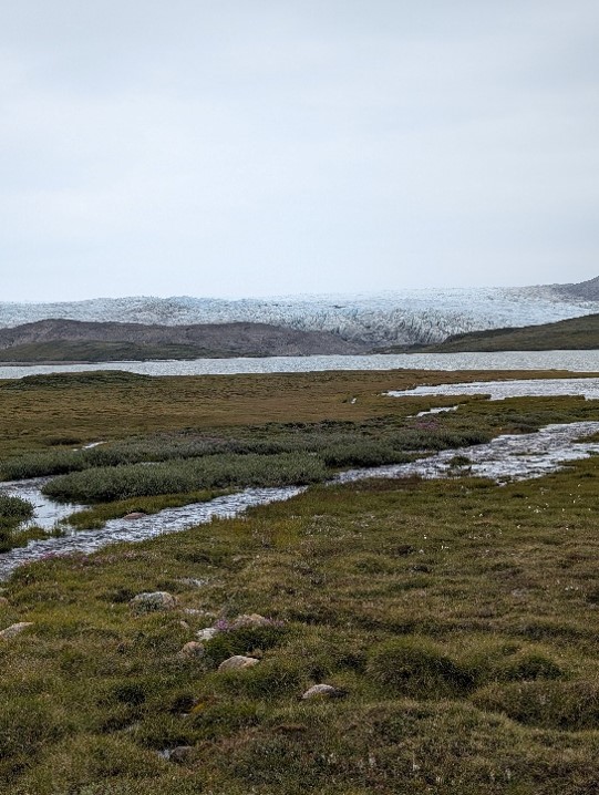
Figure 1: Typical landscape near to the Greenland Ice Sheet in West Greenland, showing developing hydrological connectivity across the landscape.
This project does not offer a CASE studentship
Each host has a slightly different application process.
Find out how to apply for this studentship.
All applications must include the CENTA application form.
Choose your application route
The project will combine geospatial analysis and hydrological modelling to investigate connectivity-driven transport processes across cold-region catchments. Available hydrological, meteorological and environmental datasets from selected study regions will be used to characterise seasonal changes in subsurface conditions, soil moisture and runoff behaviour. Spatial analyses will draw on suitable elevation data and hydrological routing approaches to delineate catchments and identify potential source, transport and storage zones.
A set of plausible environmental-change scenarios will be developed from field observations in Arctic and/or Alpine environments and relevant literature. These will explore how shifts in infiltration, subsurface storage and runoff generation may alter hydrological connectivity. Model outputs will be assessed using appropriate observational or regional datasets, depending on data availability, and interpreted alongside relevant measurements of soils, sediments, nutrients and carbon (and potentially including lacustrine diatom and pigment analysis from short sediment cores) to examine controls on biogeochemical transport across deglaciating landscapes.
DRs will be awarded CENTA Training Credits (CTCs) for participation in CENTA-provided and ‘free choice’ external training. One CTC can be earned per 3 hours training, and DRs must accrue 100 CTCs across the three and a half years of their PhD.
The doctoral researcher will receive training in spatial hydrology, GIS, environmental modelling, statistical analysis, remote sensing and Arctic/Alpine field methods (potentially including palaeolimnology and sedimentary proxy analysis, following discussion with the DR). Additional training will be provided in cryosphere science, biogeochemistry, scientific programming (R and Python), reproducible workflows and interdisciplinary environmental research. Fieldwork opportunities in Greenland and/or Switzerland, and participation in UKCEH and CENTA training programmes will provide practical experience in environmental monitoring, data collection and stakeholder engagement. The project will offer extensive opportunities for developing quantitative, computational and interdisciplinary research skills applicable across environmental science, academia and industry.
UK Centre for Ecology & Hydrology (UKCEH
The project will be developed collaboratively between Loughborough University and UKCEH, combining expertise in hydrological modelling, spatial analysis, Arctic environmental change and biogeochemistry. Both host partners will contribute existing datasets, Arctic/Alpine field expertise and supervision in soil hydrology and nutrient cycling. Additional collaboration will be sought with Greenland-based monitoring programmes and ongoing cryosphere projects that provide hydrological and meteorological observations. The supervisory team will ensure strong integration between modelling, field observations and environmental process understanding.
Year 1: Literature review; training; synthesis of existing Greenland datasets; development of conceptual framework; catchment delineation and hydrological connectivity analyses; identification of field sites.
Year 2: Implementation of hydrological modelling workflows; development and testing of thaw scenarios; fieldwork and environmental sampling (likely 1-2 weeks); preliminary analysis of hydrological and biogeochemical datasets.
Year 3: Integration of modelling and field observations; assessment of carbon, nutrient and sediment transport pathways; cross-site comparison; preparation of publications.
Final 6 months: Thesis completion, manuscript submission, dissemination activities and conference presentations (NB key conferences earlier in the PhD will also be considered/targeted as appropriate).
Andresen, C.G., Lawrence, D.M., Wilson, C.J., McGuire, A.D., Koven, C., Schaefer, K., Jafarov, E., Peng, S., Chen, X., Gouttevin, I., Burke, S., Chadburn, S., Ji, D., Chen, G., Hayes, D. and Zhang, W. (2020) ‘Soil moisture and hydrology projections of the permafrost region – a model intercomparison’, The Cryosphere, 14, pp. 445–459. doi:10.5194/tc-14-445-2020.
Bui, M.T., Lu, J. and Nie, L. (2020) ‘A Review of Hydrological Models Applied in the Permafrost-Dominated Arctic Region’, Geosciences, 10(10), 401. doi:10.3390/geosciences10100401.
Mankoff, K.D., Noël, B., Fettweis, X., Ahlstrøm, A.P., Colgan, W., Kondo, K., Langley, K., Sugiyama, S., van As, D. and Fausto, R.S. (2020) ‘Greenland liquid water discharge from 1958 through 2019’, Earth System Science Data, 12, pp. 2811–2841. doi:10.5194/essd-12-2811-2020.
van As, D., Hasholt, B., Ahlstrøm, A.P., Box, J.E., Cappelen, J., Colgan, W., Fausto, R.S., Mernild, S.H., Mikkelsen, A.B., Noël, B.P.Y., Petersen, D. and van den Broeke, M.R. (2018) ‘Reconstructing Greenland Ice Sheet meltwater discharge through the Watson River (1949–2017)’, Arctic, Antarctic, and Alpine Research, 50(1), e1433799.
For further information about this project, please contact Prof Dave Ryves ([email protected]), Department of Geography and Environment, Loughborough University, or Dr Maud van Soest ([email protected]), UK Centre for Ecology & Hydrology.
To apply to this project:
Applications must be submitted by 23:59 GMT on Wednesday 6th January 2027.