Project highlights
- Generating new knowledge on coastal landslide processes using novel in-situ technology, and remote sensing.
- Advancing InSAR methods for the detection of small-scale mass movements
- Evaluating impacts of landslides on conservation of coastal areas in the context of climate change.
Overview
Many UK coastal areas face threats from rapid erosion, cliff retreat, and landslides (Figure 1). These threats are likely exacerbated by climate change, sea-level rise and shifting rainfall patterns. Additionally, human activities, including infrastructure development and coastal engineering practices can disrupt natural coastal dynamics. Coastal defences, designed for protection, sometimes inadvertently contribute to a phenomenon known as “coastal catch-up,” where underlying coastal processes persist, leading to sudden and potentially disruptive consequences1,2. The UK coastline encompasses numerous “Sites of Special Scientific Interest” (SSSIs) that are vital natural areas for conserving unique ecosystems, species, and geological features. These SSSIs span diverse habitats, including woodlands, wetlands, and coastal zones, and play a pivotal role in biodiversity conservation3,4. Beyond their ecological significance, SSSIs also provide controlled environments for scientific research and offer essential ecosystem services such as clean air, water, pollination, carbon storage, and flood mitigation.
Natural England plays a pivotal role in safeguarding SSSIs through monitoring, threat assessment, and long-term monitoring plans. To address the complex challenges posed by the dynamic nature of coastal areas and their intersection with conservation efforts, the project takes a unique, multidisciplinary approach by integrating geological, ecological, climatological, and engineering perspectives. This approach aims to enhance our understanding of coastal landslides and their impact on conservation efforts, providing insights into how conservation areas may evolve under the influence of landslide processes and guiding effective management strategies.
The project’s specific objectives include improving our comprehension of coastal landslides, their interactions with climate change factors, and their responses to shifting rainfall patterns, increased storminess, and rising sea levels. It will develop dynamic indices to assess the susceptibility of specific SSSIs to landslides over time, supporting condition assessments and land-use decisions. Additionally, the research will examine the short- and long-term effects of coastal landslides on the boundaries and physical characteristics of SSSIs, with a particular focus on SSSIs linked to biodiversity conservation or sensitive to infrastructure development, such as carbon storage facilities and offshore wind farms. Furthermore, the project will investigate the role of coastal engineering practices in exacerbating coastal landslides, potentially leading to the loss of SSSIs.
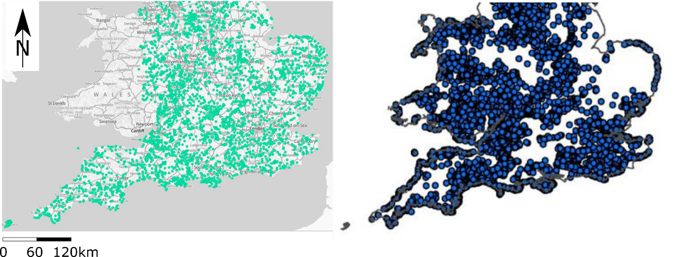
Figure 1. Maps of England and Wales showing overlap along coasts between SSSIs (left, from magic.defra.gov.uk) and landslides (right, from BGS).
CENTA Flagship
This is a CENTA Flagship Project
Case funding
This project is suitable for CASE funding
Host
University of BirminghamTheme
- Dynamic Earth
Supervisors
Project investigator
Dr Benedetta Dini (University of Birmingham, [email protected])
Co-investigators
Dr Jon Carey (University of Birmingham, [email protected])
Dr Nish Halwyn (Natural England, [email protected])
Dr Elizabeth Hopley (Natural England, [email protected])
Dr Stefania Anastasia Schinaia (Natural England, [email protected])
Dr Louise Denning (Natural England, [email protected])
Dr Barbara Silva ([email protected])
How to apply
- Each host has a slightly different application process.
Find out how to apply for this studentship. - All applications must include the CENTA application form. Choose your application route
Methodology
- Data collection – historical landslide data (BGS), past rainfall records, sea-level rise trends (CEFAS), coastal engineering records (Channel Coast Observatory)
- Mapping changes at SSSIs using historical satellite imagery (e.g., Planet Lab, Sentinel2, Digimaps) and GIS databases (NE). Select study sites for in-depth study based on vulnerability to landslides and significance of SSSIs (potential sites: Sheppey Cliffs, Kent; Axmouth-Lyme Regis, Devon; Sidestrand/Trimingham, Norfolk; Black Ven, Dorset).
- InSAR (synthetic aperture radar differential interferometry) processing at UoB to detect past and ongoing ground movements over selected stretches.
- Instrumentation with low-cost sensors (UoB), consulting with Natural England.
- Data analysis – examine correlations between historical rainfall events, sea-level rise, and changes in SSSIs, including landslides and erosion. Assess recent trends’ impact on ground movements and SSSI alterations.
- Coastal engineering. Investigate coastal engineering’s impact on “coastal catchup” and analyse the effects of defences on sediment transport and SSSI stability.
Training and skills
Students will be awarded CENTA2 Training Credits (CTCs) for participation in CENTA2-provided and ‘free choice’ external training. One CTC equates to 1⁄2 day session and students must accrue 100 CTCs across the three years of their PhD.
The candidate will be trained on large database generation and management using data from different sources and proficient use of GIS, key for hazard assessment skills. The candidate will benefit from training on field geomorphological mapping of landslides and sites of special interest. In addition, the candidate will use standard InSAR applications for targeted landslide analyses and may have the opportunity to develop methods aimed at radar signal extraction over large datasets. Finally, the candidate will be trained to select sites for instrumentation, to carry out network setup and to work on accelerometer time series obtained from IoT-based low-cost sensors.
Partners and collaboration
This project will allow the student to collaborate with Natural England and interact with their coastal geomorphology research team. In addition, there are opportunities for international travel and collaboration through a network of research partners, workshops, and conferences.
Further details
Further details on how to contact the supervisor for this project and how to apply for this project can be found here:
For any enquiries related to this project please contact Dr Benedetta Dini, [email protected].
To apply to this project:
- You must include a CENTA studentship application form, downloadable from: CENTA Studentship Application Form 2024.
- You must include a CV with the names of at least two referees (preferably three) who can comment on your academic abilities.
- Please submit your application and complete the host institution application process via: https://sits.bham.ac.uk/lpages/LES068.htm. Please select the PhD Geography and Environmental Science (CENTA) 2024/25 Apply Now button. The CENTA application form 2024 and CV can be uploaded to the Application Information section of the online form. Please quote CENTA 2024-B10 when completing the application form.
Applications must be submitted by 23:59 GMT on Wednesday 10th January 2024.
Possible timeline
Year 1
Data collection, generation of database, study site selection, begin mapping changes, field instrumentation.
Year 2
Continuing mapping changes, initiate InSAR analyses and interpretation, analyse accelerometer data.
Year 3
Interpretation of movement rates, changes and assess recent trends’ impacts on ground movements and SSSI changes.
Further reading
- Dornbusch, U. & Mylroie, P. Examples of coastal catch-up including barrier roll-back, marsh and brick-earth cliff erosion in Southeast England. in Coasts, Marine Structures and Breakwaters 2017: Realising the Potential 83–92 (ICE Publishing, 2018).
- Kantamaneni, K., Rice, L., Du, X., Allali, B. & Yenneti, K. Are Current UK Coastal Defences Good Enough for Tomorrow? An Assessment of Vulnerability to Coastal Erosion. Coast. Manag. 50, 142–159 (2022).
- Ellis, N. A history of the geological conservation review. Geol. Soc. London, Spec. Publ. 300, 123–135 (2008).
- Prosser, C. D. The history of geoconservation in England: legislative and policy milestones. Geol. Soc. London, Spec. Publ. 300, 113–122 (2008).