Project highlights
- Improve our understanding of landslide prediction, by focusing on the temporal aspects of landslide susceptibility.
- The identification of preferred failure timings as well as an understanding of the underpinning controls will represent a step-change in landslide risk analysis.
- The student will gain a key set of analytical skills that will be of high relevance and importance for a future career in research, private or public sectors.
Overview
Landslides produce an estimated €6Bn in damage to global infrastructure and cause 14000 deaths per year worldwide. These figures are likely to be underestimates. Improving our understanding of landslide risk is therefore of critical economic and societal importance. Our current understanding of landslide risk has largely focused on defining and monitoring locations considered at risk from landslides, whether slow-moving or catastrophic. This has greatly improved our understanding of where landslides are likely to occur, however, we lack comparable understanding and progress on when these landslides are likely to occur. This critical knowledge gap places a significant uncertainty in landslide risk management, which this project seeks to help address.
Our preliminary database1–3 compilation and analysis of global landslide timing reveals a profound diurnal pattern, namely that the vast majority of landslides occur between 15:00 and 23:00, regardless of their global location, time of year, or climate (Figure 1). This yet unacknowledged strong constraint on the daily timing of landslides suggests an important role of daily temperature variations on e.g., pore water pressure and water viscosity in triggering landslides. This project will seek to explore this important constraint in landslide timing and determine the likely mechanisms and their variation, across the globe. In this context, the project will consider how landslide characteristics (size, materials, failure mechanism and, potentially, history) and environmental variables (terrain and landscape characteristics, as well as meteorological parameters) influence the observed failure timings. This is key to enhance landslide predictability. Specifically, this project will ask 1) how strong are the global signals on landslide occurrence at sub-daily, daily, seasonal, and annual timescales, 2) what are the key drivers, and how identification varies across temporal scales, and 3) how can this new understanding on temporal constraints better inform our understanding and modelling of landslide risk. This project’s unique focus on landslide timing will provide much-needed progress on timing controls on landslide risk, directly relevant to industry partners, especially within engineering and insurance sectors.
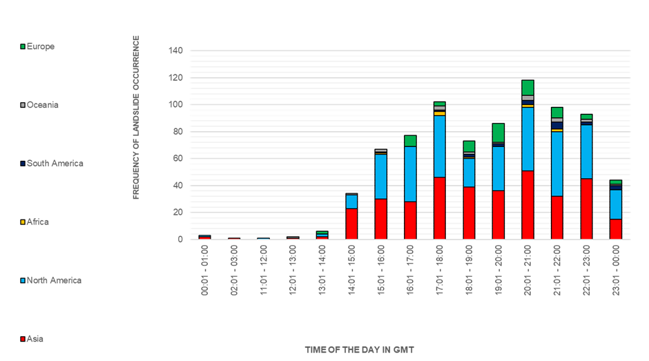
Figure 1: Stacked bar chart showing preferred times of landslide occurrence. Preferred times: between 15 and 23. Sub-bars represent continents and show no evidence for large differences across world’s regions. (Sources: Froude and Petley, 2018; Kirschbaum et al., 2010; Kirschbaum et al., 2015).
Host
University of BirminghamTheme
- Climate and Environmental Sustainability
- Dynamic Earth
Supervisors
Project investigator
Dr Joshua Larsen (University of Birmingham, [email protected])
Co-investigators
Dr Benedetta Dini (University of Birmingham, [email protected])
Dr Jon Carey (University of Birmingham [email protected])
Dr Claire Dashwood (British Geological Survey, [email protected])
How to apply
- Each host has a slightly different application process.
Find out how to apply for this studentship. - All applications must include the CENTA application form. Choose your application route
Methodology
- Data compilation and collection. Compile an integrated database from available global landslide databases, including location, timing and characteristics. This might involve quality checks, merging features and optical imagery analysis to complement attributes. Collect relevant historical meteorological data for a selected region (rainfall, temperature).
- Preliminary data analysis. Perform analyses (e.g., statistical analyses) to identify/confirm patterns in landslide timing. Determine diurnal and seasonal patterns.
- Mechanism investigation and lab experiments. Explore potential mechanisms underlying diurnal pattern of landslides with focus on pore pressure (UK sites). Investigate factors such as pore water pressure and viscosity.
- Geographic and environmental analysis. Extensive GIS-based analysis to investigate influence of terrain and other landscape characteristics on landslide timing.
- Temporal analysis. Examine the strength of global signals regarding landslide occurrence at different temporal scales, including sub-daily, daily, seasonal, and annual. Identify key drivers of landslide timing and investigate how their significance varies across temporal scales.
Training and skills
Students will be awarded CENTA2 Training Credits (CTCs) for participation in CENTA2-provided and ‘free choice’ external training. One CTC equates to 1⁄2 day session and students must accrue 100 CTCs across the three years of their PhD.
This project offers a chance to develop key skills in analysing environmental datasets. The student will learn to generate high-quality, databases, achieving professional-level proficiency in GIS—a key geography tool. The candidate will learn data manipulation techniques for time series and landscape analysis. The candidate will acquire fundamental knowledge in geomorphology, hydrology, and landslide analysis, integrated with meteorological data analysis. Remote sensing, or optical image analysis to identify landslide characteristics will be used. In the laboratory, the candidate will develop skills to design undertake standard and advanced laboratory testing to understand landslide mechanisms.
Partners and collaboration
This project will allow the student to collaborate with the British Geological Survey (BGS) and interact with their landslide research team. In addition, there are opportunities for international travel and collaboration through a network of research partners, workshops, and conferences.
Further details
Further details on how to contact the supervisor for this project and how to apply for this project can be found here:
For any enquiries related to this project please contact Josh Larsen ([email protected]).
To apply to this project:
- You must include a CENTA studentship application form, downloadable from: CENTA Studentship Application Form 2024.
- You must include a CV with the names of at least two referees (preferably three) who can comment on your academic abilities.
- Please submit your application and complete the host institution application process via: https://sits.bham.ac.uk/lpages/LES068.htm. Please select the PhD Geography and Environmental Science (CENTA) 2024/25 Apply Now button. The CENTA application form 2024 and CV can be uploaded to the Application Information section of the online form. Please quote CENTA 2024-B28 when completing the application form.
Applications must be submitted by 23:59 GMT on Wednesday 10th January 2024.
Possible timeline
Year 1
Data compilation, quality checks, feature merging. Collection of meteorological data for a selected region. Preliminary analysis for patterns identification.
Year 2
Mechanisms investigation and temporal analysis. Laboratory experiments.
Year 3
Integration of data sources and interpretation of findings. Write up.
Further reading
- Froude, M. J. & Petley, D. N. Global fatal landslide occurrence from 2004 to 2016. Nat. Hazards Earth Syst. Sci. 18, 2161–2181 (2018).
- Kirschbaum, D. B., Adler, R., Hong, Y., Hill, S. & Lerner-Lam, A. A global landslide catalog for hazard applications: method, results, and limitations. Nat. Hazards 52, 561–575 (2010).
- Kirschbaum, D., Stanley, T. & Zhou, Y. Spatial and temporal analysis of a global landslide catalog. Geomorphology 249, 4–15 (2015).