Project highlights
- Generating new knowledge of coastal landslide stability risk using advanced laboratory testing and numerical modelling techniques
- Developing new approaches to detect small scale movement using InSAR
- Evaluating future behaviour of coastal landslide complexes in response to future climate change
Overview
Landslide kill approximately 14,000 people every year globally (Petley, 2012). In most cases this is because they move rapidly and are difficult to pre-empt. Although advances in remote earth surface monitoring provide new techniques to identify and accurately measure landslide movement rates, determining if and when slow-moving landslides will accelerate catastrophically remains poorly understood. This is because these approaches cannot account for the complex movement behaviour driven by a variety of landslide types (e.g. deeper-seated basal sliding to shallow mudslides, debris flows, and cliff falls) across a landslides complex and how these different processes may evolve in response to changes in stress (e.g. rainfall and toe erosion) through time.
Many large active and dormant landslide complexes are located along the UK coastline and are likely to have initiated at the end of the last glacial maxima when sea levels and environmental conditions were considerably different to today. Given that coastal erosion rates are increasing along most of the UK coastline in response to climate and sea level change, understanding the potential response of these landslides is essential if appropriate risk assessments and cliff management are to be implemented.
Up to 80 landslide complexes have been identified along the English coastline. These complex cliff systems composed of a series of landslide units which move at different rates (Fig) and depths through a range of mechanisms, but few have been studied in detail. We will select three sites and use advanced geotechnical testing approaches to measure the strength of the materials operating each setting and simulate their potential future failure scenarios. Together with field monitoring data, remote earth surface monitoring and numerical modelling this dataset will be used to construct new ground models that evaluate how The Undercliff may evolve in response to future climate change. The study will be the first to consider how different landslide processes may develop within complex landslide systems and how this new knowledge can be used to evaluate the potential hazard they may pose in a changed and changing climate.
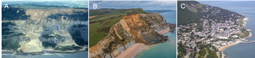
Figure. Examples of complex cliffs along the English coastline (A) Active shallow mudslides running out over deep-seated landslide at Black Ven, Dorset (Brunsden et al. 1988) (B) Large rockfall event, Seatown, Dorset (James Loveridge Photography, 2023) (C) A slow-moving Urban landslide complex at Vennor on the Isle of Wight.
CENTA Flagship
This is a CENTA Flagship Project
Case funding
This project is suitable for CASE funding
Host
University of BirminghamTheme
- Dynamic Earth
Supervisors
Project investigator
Dr Jon Carey (GEES, University of Birmingham), [email protected]
Co-investigators
Dr Benedetta Dini (GEES, University of Birmingham), [email protected]
Professor Roger Moore (Jacobs), [email protected]
Dr Xilin Xia (Engineering, University of Birmingham) [email protected]
How to apply
- Each host has a slightly different application process.
Find out how to apply for this studentship. - All applications must include the CENTA application form. Choose your application route
Methodology
The study will comprise:
- Field mapping and review of existing data to explore the historical contemporary behaviour of three different landslide sites.
- Processing of Sentinel-1 radar images from 2014 to present to generate high resolution interferograms and map potential instabilities within the Undercliff and how they change through time.
- Laboratory testing on landslide materials using an advanced back-pressured shear box including:
- conventional strength testing on basal materials in characteristic landslides along The Undercliff, and
- specialist porewater pressure-controlled shear experiments that simulate potential rainfall scenarios to evaluate potential future failure mechanisms.
- Numerical modelling of the landslides using:
- lab-scale FEM/DEM calibration in FLAC/UDEC against laboratory testing and validation based on field-scale observations (geomorphology), and (b)
- runout modelling using RAMMS to back-analyse existing landslides and output potential runout parameters that could inform future hazard assessment.
Training and skills
Students will be awarded CENTA2 Training Credits (CTCs) for participation in CENTA2-provided and ‘free choice’ external training. One CTC equates to 1⁄2 day session and students must accrue 100 CTCs across the three years of their PhD.
In the field the candidate will be trained to carry out field geomorphological mapping of coastal hazards. In the laboratory they will develop skills to design undertake standard and advance laboratory testing that aims at understanding landslide movement mechanisms which they will then learn to upscale using numerical modelling. In addition, they will be trained to use standard InSAR applications and use these to undertake targeted analyses for mass movements. Combining these skills will allow the candidate to interpret complex process operating in active landscapes and how these may be impacted by climate change.
Partners and collaboration
This project is of direct relevance to costal hazard practitioners as forecasting future cliff recession rates and the potential behaviour of complex cliffs remains a key change in coastal management. The proposed project will be co-supervised by Professor Roger Moore, who is a Director and Global Principal in Geoscience Engineering at Jacobs. Professor Moore is a leading expert in UK coastal landslides and will provide his technical expertise to support training in geomorphological mapping and landslide hazard assessment. Roger will be key in determining the most appropriate sites for the study.
Further details
Further details on how to contact the supervisor for this project and how to apply for this project can be found here:
For any enquiries related to this project please contact Dr Jon Carey, [email protected].
To apply to this project:
- You must include a CENTA studentship application form, downloadable from: CENTA Studentship Application Form 2024.
- You must include a CV with the names of at least two referees (preferably three) who can comment on your academic abilities.
- Please submit your application and complete the host institution application process via: https://sits.bham.ac.uk/lpages/LES068.htm. Please select the PhD Geography and Environmental Science (CENTA) 2024/25 Apply Now button. The CENTA application form 2024 and CV can be uploaded to the Application Information section of the online form. Please quote CENTA 2024-B5 when completing the application form.
Applications must be submitted by 23:59 GMT on Wednesday 10th January 2024.
Possible timeline
Year 1
Fieldwork and InSAR analyses to develop initial ground models for each landslide site.
Year 2
Laboratory testing and numerical modelling.
Year 3
Finalise numerical modelling and write up of results.
Further reading
Journal:
Brunsden, D., Gardner, R., Goudie, A. and Jones, D. (1988) Land Shapes, Channel 4.
Carey, J. M., Massey C.I., Lyndsell B., Petley D. N. (2019) Displacement mechanisms of slow-moving landslides in response to changes in porewater pressure and dynamic stress. Earth Surface Dynamics 7, pp. 707- 722 .
Carey, J.M., Moore, R. & Petley, D.N. (2015) Patterns of movement in the Ventnor landslide complex, Isle of Wight, southern England, Landslides, 12, pp.1107–1118
Carey, J. M., Petley D. N. (2014) Progressive shear-surface development in cohesive materials; implications for landslide behaviour, Engineering Geology, 177, pp. 54-65.
Dini, B., Daout, S., Manconi, A., Loew, S. (2019) Classification of slope processes based on mulitemporal DInSAR analyses in the Himalaya of NW Bhutan, Remote Sensing of Environment 233, 11408. doi.org/10.1016/j.rse.2019.111408.
Dini, B., Manconi, A., Loew, S. (2019) Investigation of slope instabilities in NW Bhutan as derived from systematic DInSAR analyses, Engineering Geology, 259, 10511. Doi.org/10.1016/j.enggeo.2019.04.008.
Petley, D.N. (2012) Global patters of loss of life from landslides, Geology, 40 (10), pp. 927-930.
Petley D. N., Higuchi T., Petley D. J., Bulmer M. H., Carey J. (2005) The development of progressive landslide failure in cohesive materials, Geology 33, pp. 201-204.
Hutchinson, J. N., Bromhead, E. N. (2002) Keynote paper: Isle of Wight landslides. In: McInnes, R.G., Jakeways, J. (eds) Instability planning and management: seeking sustainable solutions to ground movement problems, Proceedings of International Conference, Ventnor. Thomas Telford, London, pp 3–70.
Moore, R., Lee, E. M., Clark, A. R. (1995) The Undercliff of the Isle of Wight: a review of ground behaviour. Cross Publishing, London.
Moore, R., Carey, J. M., McIness, R. G. (2010) Landslide behaviour and climate change: predictable consequences for the Ventnor Undercliff, Isle of Wight. Quarterly Journal of Engineering Geology and Hydrogeology, 43, pp. 447–460.