Project highlights
- Contributing novel insights into riverine carbon dynamics and shedding light on the environmental consequences of land use change in Southeast Asia.
- Providing evidence to inform decision-makers, benefiting conservation efforts and sustainable land management practices.
- Employing a comprehensive methodology that combines laboratory and field-based measurements, optical sensing and real-time data to provide a detailed understanding of riverine carbon dynamics.
Overview
Coastal systems annually receive 0.4-0.5 Pg of organic carbon from terrestrial sources, transported via rivers (Ciais et al., 2013). Dissolved organic carbon (DOC) is a vital component of the global carbon cycle, impacting coastal ecosystems by influencing light availability for photosynthesis and contributing to seawater acidification. Human disturbances like deforestation can enhance land-to-ocean DOC export.
Southeast Asia’s tropical peatlands have experienced extensive land-use changes, converting over 90% of peatland into agricultural land in three decades (Miettinen et al., 2016; Figure 1). This rapid transformation, among the highest globally, profoundly affects coastal DOC export. One example is northwestern Borneo’s Baram River catchment, which has seen substantial land-use changes associated with oil palm plantation expansion (Naciri et al., 2023). Recent satellite data analysis has revealed a 30% rise in coastal terrigenous DOC fluxes between 2002 and 2021, directly linked to the conversion of 69% of regional peatland into non-forest land (Sanwlani et al., 2022). Field studies in Sarawak confirm substantial terrigenous DOC inputs to coastal waters, much of which is likely to mineralise to CO2 (Martin et al., 2018).
Borneo’s peatland-draining rivers exhibit exceptionally high DOC concentrations, up to 66 mg C L−1, surpassing most global rivers. However, Southeast Asia lacks research on quantifying DOC fluxes from these rivers, with limited studies on rivers and estuaries. Only one known study, by Martin et al. (2018), specifically explored DOC transport beyond coastal waters, focusing on Sarawak’s Rajang and Maludam Rivers.
This study aims to quantify DOC fluxes from Sarawak’s Baram River, the region’s second-longest river. This represents an important carbon transport pathway from land to the ocean which appears to be influencing the Miri-Sibuti coral reef marine park. The research will contribute to understanding the environmental consequences of land-use changes and human activities on riverine carbon dynamics, providing critical insights into freshwater and marine ecosystem health and resilience.
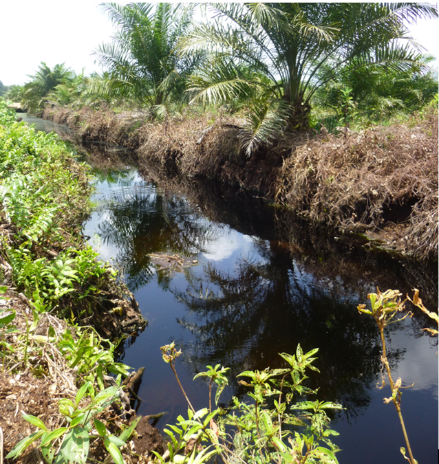
Figure 1. Artificial drainage channel in a tropical peatland oil palm plantation exporting dissolved organic carbon into a nearby river. Sarawak, Malaysia.
Host
University of LeicesterTheme
- Climate and Environmental Sustainability
Supervisors
Project investigator
Mick Whelan ([email protected]) University of Leicester
Co-investigators
Jens Zinke ([email protected]) University of Leicester
Sue Page ([email protected]) University of Leicester
Sarah Cook ([email protected]) University of Warwick
How to apply
- Each host has a slightly different application process.
Find out how to apply for this studentship. - All applications must include the CENTA application form. Choose your application route
Methodology
Existing data on discharge and water quality will be collated and analysed along with remotely sensed imagery which will be used to quantify land use change. River and sea water samples will be collected seasonally and analysed for DOC concentrations using a combination of laboratory and field-based (spectrophotometric) measurements. Field measurements will be carried out at various locations to capture spatial variation in DOC concentrations and properties. Optical methods including Specific Ultraviolet Absorbance (SUVA) will be used to provide proxy composition metrics on the bulk DOC pool. Discharge data at existing gauging stations will be checked and, if necessary supplemented by instrumentation giving real-time data. Hydrological and biogeochemical models will be developed to give insights into the relationships between hydrological response and water quality, seasonally and in response to land use change .
The student will also use remote sensing data of chromophoric DOC (CDOM) in sea water and assess the extent to which this correlated with coral luminescence coring data (available for the last 100 years). This will allow us to estimate long-term trends in organic carbon fluxes (Kaushal et al., 2021).
Training and skills
The student will develop a diverse skill set including laboratory and field techniques for assessing DOC concentrations and fluxes. They will gain proficiency in spectrophotometric analyses (e.g. SUVA254), to assess the composition and properties of the bulk DOC pool. Fieldwork will involve sample collection and hydrological measurement at various sites, to understand spatial and seasonal variations in DOC concentrations and loads. The student will also acquire skills in remote sensing, data analysis and numerical modelling.
Students will be awarded CENTA2 Training Credits (CTCs) for participation in CENTA2-provided and ‘free choice’ external training. One CTC equates to 1⁄2 day session and students must accrue 100 CTCs across the three years of their PhD.
Partners and collaboration
The supervisory team have a range of relevant research expertise covering tropical peatland carbon dynamics, including DOC fluxes, tropical land use change, hydrological modelling and the study of sedimentary archives in tropical oceans as records of environmental and climate change. Previous and current research by the supervisory team includes quantification of DOC fluxes from oil palm plantations on peat in Sarawak and the importance of corals as archives of tropical land use change.
Further details
Further details on how to contact the supervisor for this project and how to apply for this project can be found here:
For any enquiries related to this project please contact Mick Whelan ([email protected]).
To apply to this project:
- You must include a CENTA studentship application form, downloadable from: CENTA Studentship Application Form 2024.
- You must include a CV with the names of at least two referees (preferably three) who can comment on your academic abilities.
- Please submit your application and complete the host institution application process via: https://le.ac.uk/study/research-degrees/funded-opportunities/centa-phd-studentships. Please scroll to the bottom of the page and click on the “Apply for NERC CENTA Studentship” button. Your CV can uploaded to the Experience section of the online form, the CENTA application form 2024 can be uploaded to the Personal Statement section of the online form. Please quote CENTA 2024-L10-CENTA2-SGGE6-WHEL when completing the application form.
Applications must be submitted by 23:59 GMT on Wednesday 10th January 2024.
Possible timeline
Year 1
During the first year, the project will kick off with crucial setup activities, including conducting a comprehensive literature review and defining clear research objectives. Training in essential skills will be provided, e.g. laboratory techniques, fieldwork protocols, data analysis methods, remote sensing and coding. Existing data on hydrology, water quality and remote sensing will be collated and analysed.
Year 2
The second year will be dedicated to field data collection and analysis via one or two field campaigns in the Baram river catchment and the development and application of numerical models of catchment hydrological and biogeochemical responses.
Year 3
The third year of the project will involve further data analysis and interpretation, including further modelling. This phase will also involve the preparation of research papers for publication and dissemination of data at conferences.
Further reading
Ciais, P., C. Sabine, G. Bala, L. Bopp, V. Brovkin, J. Canadell, A. Chhabra, R. DeFries, J. Galloway, M. Heimann, C. Jones, C. Le Quéré, R.B. Myneni, S. Piao and P. Thornton, 2013: Carbon and Other Biogeochemical Cycles. In: Climate Change 2013: The Physical Science Basis. Contribution of Working Group I to the Fifth Assessment Report of the Intergovernmental Panel on Climate Change [Stocker, T.F., D. Qin, G.-K. Plattner, M. Tignor, S.K. Allen, J. Boschung, A. Nauels, Y. Xia, V. Bex and P.M. Midgley (eds.)]. Cambridge University Press, Cambridge, United Kingdom and New York, NY, USA.
Kaushal, N., Sanwlani, N., Tanzil, J. T. I., Cherukuru, N., Sahar, S., Müller, M., et al. (2021). Coral skeletal luminescence records changes in terrestrial chromophoric dissolved organic matter in tropical coastal waters. Geophysical Research Letters, 48, e2020GL092130.
Martin, P., Cherukuru, N., Tan, A. S. Y., Sanwlani, N., Mujahid, A., and Müller, M.: Distribution and cycling of terrigenous dissolved organic carbon in peatland-draining rivers and coastal waters of Sarawak, Borneo, Biogeosciences, 15, 6847–6865, https://doi.org/10.5194/bg-15-6847-2018, 2018.
Miettinen, J., Shi, C., and Liew, S. C.: Land cover distribution in the peatlands of Peninsular Malaysia, Sumatra and Borneo in 2015 with changes since 1990, Glob. Ecol. Conserv., 6, 67–78, https://doi.org/10.1016/j.gecco.2016.02.004, 2016.
Naciri, W., Boom, A., Payne, M., Browne, N., Evans, N.J., Holdship, P., Rankenburg, K., Nagarajan, R., McDonald, B.J., McIlwain, J., Zinke, J., 2023. Massive corals record deforestation in Malaysian Borneo through sediments in river discharge. Biogeosciences 20, 1587–1604. https://doi.org/10.5194/bg-20-1587-2023
Sanwlani, N., Evans, C.D., Müller, M., Cherukuru, N., Martin, P., 2022. Rising dissolved organic carbon concentrations in coastal waters of northwestern Borneo related to tropical peatland conversion. Sci. Adv. 8, eabi5688. https://doi.org/10.1126/sciadv.abi5688