Project highlights
- Develop new understanding of anthropogenic emissions from point sources
- Generate evidence for joined up climate and air quality policy
- Drive the development of the next generation of satellite remote sensing techniques
Overview
As we move toward stricter air quality guidelines and more ambitious climate targets, it is imperative that we understand emissions from key point and small area sources such as power stations, mines, landfills, and other industrial facilities, in order to best target our efforts. We additionally need to monitor changes over time to evaluate the effectiveness of reduction measures. To do this on a global scale we must utilise current and future satellite technologies and high-resolution atmospheric models.
This project will utilise current satellite data and the cutting-edge model WRF-Chem to understand greenhouse gas and air pollutant emissions from important point sources including power stations, mines, and landfills. Evaluation of performance of satellite data will be conducted, and evidence for policy pathways explored. Data from Sentinel 5P TROPOMI will be used in the first instance, with a focus on nitrogen dioxide and methane emission quantification. This will be coupled with the WRF-Chem model. Requirements for future data streams will be defined, with a view to satisfying the needs of policy decisionmakers of the future.
A key element of this PhD will be understanding how environmental data products and analysis can be generated to best meet the needs of policy stakeholders. The supervisory team have strong links with local, national and international policy stakeholders in both air pollution and greenhouse gas contexts.
In addition to providing evidence for policy, this PhD will also develop advice on what future satellite observations are needed, and feed into building the case for future missions for air quality and greenhouse gas remote sensing, to ensure that future generations have a high quality long term record of point source emissions as policies and technologies evolve.
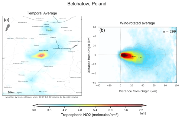
Figure 1: An example of resolving industrial emissions by combining satellite data with models. Here nitrogen dioxide emissions from a power station in Belchatow, Poland observed from TROPOMI are averaged (a) compared to wind-rotated and averaged (b) through application of ECMWF ERA5 data to illustrate how emissions can be resolved. Reproduced from Potts et al., 2023.
Host
University of LeicesterTheme
- Climate and Environmental Sustainability
Supervisors
Project investigator
Josh Vande Hey, University of Leicester
Co-investigators
Harj Sembhi, University of Leicester
Emma Ferranti, University of Birmingham
How to apply
- Each host has a slightly different application process.
Find out how to apply for this studentship. - All applications must include the CENTA application form. Choose your application route
Methodology
Data from Sentinel 5P TROPOMI will be used in the first instance, with a focus on nitrogen dioxide and methane emission quantification from important point sources. This will be coupled with the WRF-Chem model. You will first apply existing methodologies to quantifying emissions of these two gases, and relate those to other emissions. You will then build upon these methods to develop new techniques and expand to additional atmospheric species. Following this, you will generate a novel point source emissions catalogue for greenhouse gas and air pollutant emissions, compare these to bottom-up estimates calculated for the facilities, and put this information into a format actionable by policy stakeholders and site operators. You will then utilise these data to conduct joined up analysis for targeted emission reduction measures in the context of joined up air quality and climate change policy development.
Training and skills
Students will be awarded CENTA2 Training Credits (CTCs) for participation in CENTA2-provided and ‘free choice’ external training. One CTC equates to 1⁄2 day session and students must accrue 100 CTCs across the three years of their PhD.
You will develop advanced programming and data analysis skills for satellite and model data processing. This will include python programming, spatio-temporal analysis and statistical methods for quantifying emissions. You will gain experience understanding environmental policy evidence requirements and develop your communication skills to engage with them. You will additionally build a strong understanding of satellite instrumentation in order to be able to interpret satellite data and provide advice on future science and policy missions. You will work as part of an interdisciplinary team of researchers in environmental science and policy.
Partners and collaboration
Your PhD will involve engagement with national government departments and stakeholders, national and international space agencies, and local authorities in the UK. You will also engage with emerging commercial satellite mission operators.
Further details
Further details on how to contact the supervisor for this project and how to apply for this project can be found here:
Interested applicants are encouraged to contact Dr. Josh Vande Hey before applying at [email protected].
To apply to this project:
- You must include a CENTA studentship application form, downloadable from: CENTA Studentship Application Form 2024.
- You must include a CV with the names of at least two referees (preferably three) who can comment on your academic abilities.
- Please submit your application and complete the host institution application process via: https://le.ac.uk/study/research-degrees/funded-opportunities/centa-phd-studentships. Please scroll to the bottom of the page and click on the “Apply for NERC CENTA Studentship” button. Your CV can uploaded to the Experience section of the online form, the CENTA application form 2024 can be uploaded to the Personal Statement section of the online form. Please quote CENTA 2024-L16-CENTA2-PHYS6-VAND when completing the application form.
Applications must be submitted by 23:59 GMT on Wednesday 10th January 2024.
Possible timeline
Year 1
Develop satellite data processing and modelling skills for atmospheric emissions quantification. Apply existing methods to study a range of point sources of greenhouse gases and air pollutants.
Year 2
Engage with environmental policy stakeholders to understand their requirements on satellite data emissions estimates. Develop new and improved techniques for emissions quantification.
Year 3
Apply new methods to a wide range of important point sources around the globe, develop targeted quantified point source emissions inventories, and evaluate the relative importance of the sources with a view to monitoring the impact of emission reduction measures in the future.
Throughout your PhD you will engage with your supervisory team who will help you develop the skills you need for each step of your research, as well as international collaborators.
Further reading
Potts, D. A., Timmis, R., Ferranti, E. J. S., and Vande Hey, J. D.(2023): Identifying and accounting for the Coriolis effect in satellite NO2 observations and emission estimates, Atmos. Chem. Phys., 23, 4577–4593, https://doi.org/10.5194/acp-23-4577-2023.
European Space Agency (2022) https://www.esa.int/Applications/Observing_the_Earth/Copernicus/Sentinel-5P/Methane_detected_over_Poland_s_coal_mines (Accessed 14 September, 2023)