Project highlights
- The project will identify the causes and impacts of extreme fire events, such as the recent fires in Amazonia, Western USA, Australia and the Arctic. It will inform policy and fire managers and contribute to vital information needed for NetZero financing.
- Will develop a state-of-the-art Wildfire Digital Twin, incorporating land surface modelling, earth observation data and machine learning to allow attribution of extreme fire events.
- Provides an opportunity to contribute to a large multi-disciplinary international project (https://www.isimip.org/) and collaborate very closely (including via placements) with scientists within the UK Met Office and UKCEH.
Overview
Extreme wildfire events, like those making global headlines over the last few years, are becoming more frequent worldwide. These fires cause enormous ecosystem damage and release vast amounts of carbon, affecting society, the climate and the wider Earth System. However, how much climate change and human landscape management exacerbate these fire events is difficult to determine due to the complex and highly non-linear interactions of multiple fire drivers. Attributing direct human involvement in forest loss due to fire is particularly important, given the vital role deforestation reduction financing will have in mitigating future climate change.
Digital Twins are an emerging paradigm in environmental and climate science. They incorporate Earth System modelling, observational data (e.g. Earth Observation) and Artificial Intelligence to produce digital simulations of the Earth capable of providing advanced science-based and data-led stakeholder decision support.
We are entering a period with an unprecedented wealth of satellite observations. Alongside significant advancements in modelling within fire-enabled models such as JULES-INFERNO and ConFire, we can now start to tackle these challenges. The growth in the quantity and capability of satellite observations offers an excellent opportunity to evaluate and constrain fire processes and feedbacks on the climate, both from observations of fires themselves and many associated parameters (land surface temperature, soil moisture, biomass) that influence their behaviour.
There has also been a recent step-change in machine learning and data assimilation. This project will explore these state-of-the-art methods for bringing together large volumes of satellite observations with highly complex model output, leading to opportunities for developing novel analyses. In particular, we will explore machine learning emulation to allow additional explainability of the model outputs and a better understanding of the uncertainty associated with the model predictions.
The PhD outputs will inform deforestation and emission reduction efforts by assessing forest vulnerability to recent and future fires associated with climate change and attributing near-real-time forest loss to natural, climate change-driven, and direct human-caused burning.
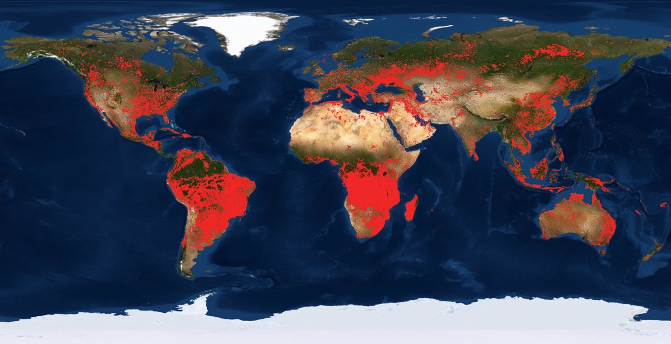
Figure 1: Much of the world is burning at any time, impacting both humans and the environment. This map shows fires detected from satellite data for August 2021 from NASA’s Fire Information for Resource Management System (FIRMS) (https://earthdata.nasa.gov/firms).
CENTA Flagship
This is a CENTA Flagship Project
Case funding
This project is suitable for CASE funding
Host
University of LeicesterTheme
- Climate and Environmental Sustainability
Supervisors
Project investigator
Dr Robert Parker, University of Leicester, [email protected]
Co-investigators
Professor Kevin Tansey, University of Leicester, [email protected]
Dr Chantelle Burton, UK Met Office, [email protected]
Dr Doug Kelley, UK Centre for Ecology and Hydrology, [email protected]
How to apply
- Each host has a slightly different application process.
Find out how to apply for this studentship. - All applications must include the CENTA application form. Choose your application route
Methodology
The student will be able to take advantage of recent advances in fire modelling and novel data-model fusion techniques to investigate new methods for analysing satellite observations to evaluate and constrain present-day fire climate feedbacks.
The student will adopt modern numerical techniques such as machine learning/data assimilation to confront the model with satellite data.
The student will develop an explainable machine-learning based emulator for the JULES-INFERNO model, allowing the importance of the different driving factors to be analysed. Incorporating ConFire’s Bayesian approach will account for uncertainty in fire drivers and biases in simulated fire impacts – allowing assessment of the confidence in attributing the cause of fire events to particular drivers.
The student will perform state-of-the-art simulations with JULES carried out using the ISIMIP framework to evaluate the ability to represent fires in future climate scenarios and utilise the emulator to examine how any climate response evolves.
Training and skills
Students will be awarded CENTA2 Training Credits (CTCs) for participation in CENTA2-provided and ‘free choice’ external training. One CTC equates to 1⁄2 day session and students must accrue 100 CTCs across the three years of their PhD.
NCEO will provide access to its Researcher Forum, staff conferences/workshops and national-level training.
There will be the opportunity to receive training at the UK Met Office and UKCEH related to using and analysing the JULES land-surface model. Training by UKCEH will cover Bayesian optimization methods and probabilistic programming, including using the ConFire attribution system.
We will provide training on the Earth System Model Evaluation Tool (ESMValTool) and data processing on the ALICE (Leicester) and JASMIN (NERC) HPC facilities.
The student will take the MSc module GY7709 (Satellite Data Analysis in Python) at UoL and other modules deemed suitable.
Partners and collaboration
This project has been developed in collaboration with the UK Met Office and UK Centre for Ecology and Hydrology, who will co-supervise the project.
In addition, a variety of other collaborations include:
- European Space Agency – Climate Change Initiative (via Dr Parker, ESA Greenhouse Gas CCI and ESA CCI Climate Modelling User Group)
- NCEO collaborators working on JULES analysis and machine-learning emulation (at University of Leicester and University of Reading)
- JULES land surface modelling (via HEIs and NERC Centres)
- Digital Twin modelling activities (via NERC and ESA)
- TerraFIRMA (NERC Long-term Science Multi-Centre project)
Further details
Further details on how to contact the supervisor for this project and how to apply for this project can be found here:
We would very strongly encourage anyone considering an application to get in touch with us in advance for an informal chat about the project at an early stage of any application.
Please contact us at: Dr Robert Parker – University of Leicester – [email protected].
To apply to this project:
- You must include a CENTA studentship application form, downloadable from: CENTA Studentship Application Form 2024.
- You must include a CV with the names of at least two referees (preferably three) who can comment on your academic abilities.
- Please submit your application and complete the host institution application process via: https://le.ac.uk/study/research-degrees/funded-opportunities/centa-phd-studentships. Please scroll to the bottom of the page and click on the “Apply for NERC CENTA Studentship” button. Your CV can uploaded to the Experience section of the online form, the CENTA application form 2024 can be uploaded to the Personal Statement section of the online form. Please quote CENTA 2024-L19-CENTA2-PHYS3-PARK when completing the application form.
Applications must be submitted by 23:59 GMT on Wednesday 10th January 2024.
Possible timeline
Year 1
Literature review and refinement of research questions. Training and familiarisation with JULES land surface mode, initial JULES simulations using the ISMIP framework. Training regarding techniques for incorporating observations and model output. Potential placements (COVID-dependent) at UKCEH (Wallingford) and/or UK Met Office.
Year 2
Development of machine-learning based emulator to contribute to explainability of JULES output. Analysis to incorporate new satellite observations. Journal publication aimed at describing emulator development and performance.
Year 3
Analysis of JULES driven with ISIMIP future climate scenarios. Journal publication aimed at climate impacts related to key science questions around fire activity and the key climate drivers as identified by emulator analysis.
Further reading
- “Firing up ambition”, Nat. Clim. Chang. 10, 1 (2020). https://doi.org/10.1038/s41558-019-0680-9
- Phillips, N. and Nogrady, B., “The race to decipher how climate change influenced Australia’s record fires”, Nature 577, 610-612 (2020), https://doi.org/10.1038/d41586-020-00173-7
- Hantson, S. et al.: The status and challenge of global fire modelling, Biogeosciences, 13, 3359–3375, https://doi.org/10.5194/bg-13-3359-2016, 2016
- Kelley, D.I., Bistinas, I., Whitley, R. et al., How contemporary bioclimatic and human controls change global fire regimes. Nat. Clim. Chang. 9, 690–696, 2019, https://doi.org/10.1038/s41558-019-0540-7 – Accessible via https://core.ac.uk/download/pdf/226936315.pdf
- Burton, C. et al., Representation of fire, land-use change and vegetation dynamics in the Joint UK Land Environment Simulator vn4.9 (JULES), Geosci. Model Dev., 12, 179–193, 2019, https://doi.org/10.5194/gmd-12-179-2019
- UNEP (2022) “Spreading like Wildfire: The rising threat of extraordinary landscape fires” https://www.unep.org/resources/report/spreading-wildfire-rising-threat-extraordinary-landscape-fires