Project highlights
- Reducing a major source of uncertainty in human-driven climate feedbacks
- Working with both satellite and ground-based data, including opportunities for field work
- Combines climate data analysis, algorithm development, and data collection
Overview
Aerosols are particles suspended in the air for hours to weeks, such as grains of desert dust or droplets of acid. By scattering and absorbing light, they can alter weather by changing the atmosphere’s temperature profile. As the seeds of droplet formation, aerosols can change the properties of cloud and, thus, affect the energy budget that drives climate change. The smallest aerosols can be breathed into the lungs, and pass into blood, causing long-term illnesses and preventable deaths. Understanding where aerosols are, and how they change, is essential to predicting weather, climate, and air quality.
Aerosols are monitored in two ways: locally using particle counters, lidars, or photometers and globally using satellite imagery in the visible and infrared. Local observations can be precise but are expensive and struggle to represent regional behaviour. Global observations are comprehensive but very sensitive to their assumptions and require complex quality control. The combination of both techniques can be powerful but coincident observations can be rare (i.e. a few times a month or year).
This project will enable a more consistent source of collocated data: geostationary satellites looking at meteorological supersites. Geostationary satellites continuously monitor the same view of the Earth and, with the recent launch of Meteosat Third Generation, there are now research-grade images of the entire planet every 15 minutes suitable for aerosol-cloud retrieval. A supersite, where numerous meteorological instruments are installed alongside each other, occupies a constant position within the satellite image, simplifying data management enough that analysis can be performed by a single researcher.
The student will learn to design and implement aerosol retrievals for geostationary imagery and ground-based sensors, producing a database of collocated, synergistic observations. That will be used to address a range of scientific questions guided by the student’s interests but can include using particle counters to generate a neural network to remotely sense air quality, directly observing how aerosols alter cloud thickness and lifetime with lidar profiles, or using radar to determine the impact of aerosols on precipitation duration. Comparison against climate models is also possible.
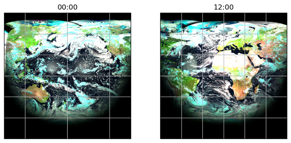
Figure 1: The Earth on 1 July 2020 as seen from geostationary orbit, using GeoRING data. In this false-colour composite, ice clouds appear light blue, liquid clouds as white, and dust as a muddy brown. Observations are continuous, so the evolution of cloud and aerosol can be monitored from both above and below.
Host
National Centre for Earth ObservationTheme
- Climate and Environmental Sustainability
Supervisors
Project investigator
Adam Povey, University of Leicester, [email protected]
Co-investigators
Josh Vande Hey, University of Leicester, [email protected]
How to apply
- Each host has a slightly different application process.
Find out how to apply for this studentship. - All applications must include the CENTA application form. Choose your application route
Methodology
Aerosol and cloud products will be generated with the Optimal Retrieval of Aerosol and Cloud (ORAC), a software package developed alongside the University of Oxford, RAL Space, Deutscher Wetterdienst, ESA’s Climate Change Initiative, and the Copernicus Climate Change Service. Geostationary observations will initially be taken from ISCCP’s GeoRING product as these are geo-rectified and calibrated, with the potential to use operational products later. A new implementation of surface reflectance will be necessary, making use of information available from the ground sites.
A collocation dataset will combine quality-controlled satellite, photometer, lidar, radar, and other observations at the same time and site. The relationships between these variables, alongside meteorological parameters such as humidity, will be examined using methods such as multivariate regression, singular value decomposition, and convolutional neural networks.
Training and skills
Students will be awarded CENTA2 Training Credits (CTCs) for participation in CENTA2-provided and ‘free choice’ external training. One CTC equates to 1⁄2 day session and students must accrue 100 CTCs across the three years of their PhD.
Statistical analysis of climatological data will underpin the scientific studies. The student will use and modify ORAC codes, learning the methods of scientific programming in Python and Fortran alongside radiative transfer and optimisation methods. Field work to collect additional ground observations, potentially at the Chilbolton Observatory, will be supported by the Field Spectroscopy Facility. Presentation and communication skills will be supported through regular, international meetings with the ORAC team and NCEO research themes.
Partners and collaboration
The Chilbolton Observatory is an STFC facility operating lidars, radars, and meteorological observations in Hampshire with a public data policy and a track record of supporting PhD students. The Field Spectroscopy Facility is a NERC facility that loans instruments to UK researchers and provides training in their use, with their portable sun photometers being relevant to this work.
Further details
Further details on how to contact the supervisor for this project and how to apply for this project can be found here:
For any enquiries related to this project please contact Adam Povey, [email protected].
The successful candidate would be registered at the University of Leicester.
To apply to this project:
- You must include a CENTA studentship application form, downloadable from: CENTA Studentship Application Form 2024.
- You must include a CV with the names of at least two referees (preferably three) who can comment on your academic abilities.
- Please submit your application and complete the host institution application process via: https://le.ac.uk/study/research-degrees/funded-opportunities/centa-phd-studentships. Please scroll to the bottom of the page and click on the “Apply for NERC CENTA Studentship” button. Your CV can uploaded to the Experience section of the online form, the CENTA application form 2024 can be uploaded to the Personal Statement section of the online form. Please quote CENTA 2024-L20-CENTA2-PHYS4-POVE when completing the application form.
Applications must be submitted by 23:59 GMT on Wednesday 10th January 2024.
The ORAC code can be accessed at https://github.com/ORAC-CC/orac.
Possible timeline
Year 1
Introduction to ORAC retrievals through reference data; Identifying suitable supersites and collecting coincident geostationary observations; Initial analysis using operational aerosol products
Year 2
Develop aerosol retrieval for a single geostationary pixel; Field work at Chilbolton Observatory to collect lidar cloud base observations; publication on variation of cloud adiabaticity with aerosol loading
Year 3
Process satellite observations to produce a collocation dataset; Sensitivity study of PM10 within that data; Demonstration of PM10 neural network at multiple supersites
Further reading
Fan, J., Y. Wang, D. Rosenfeld, and X. Liu (2016) ‘Review of Aerosol–Cloud Interactions: Mechanisms, Significance, and Challenges’, Journal of the Atmospheric Sciences, 73, pp. 4221–4252. doi:10.1175/JAS-D-16-0037.1.
Sus, O., Stengel, M., Stapelberg, S., McGarragh, G., Poulsen, C., Povey, A. C., Schlundt, C., Thomas, G., Christensen, M., Proud, S., Jerg, M., Grainger, R., and Hollmann, R. (2018) ‘The Community Cloud retrieval for CLimate (CC4CL) – Part 1: A framework applied to multiple satellite imaging sensors’, Atmospheric Measurement Techniques, 11, pp. 3373–3396. doi:10.5194/amt-11-3373-2018.
McGarragh, G. R., Poulsen, C. A., Thomas, G. E., Povey, A. C., Sus, O., Stapelberg, S., Schlundt, C., Proud, S., Christensen, M. W., Stengel, M., Hollmann, R., and Grainger, R. G. (2018) ‘The Community Cloud retrieval for CLimate (CC4CL) – Part 2: The optimal estimation approach’, Atmospheric Measurement Techniques, 11, pp. 3397–3431. doi:10.5194/amt-11-3397-2018.
EUMETSAT (2023) Meteosat Real-Time Imagery. Available at: https://eumetview.eumetsat.int/static-images/ (Accessed 14 September 20243).