Project highlights
- An exciting opportunity to learn and develop innovative topographic analysis and remote sensing tools for quantifying landscape change.
- Great potential for new insights into landscape evolution over multiple temporal and spatial scales, particularly relating to the time periods following extreme perturbations (e.g., floods, earthquakes).
- The student will gain both strong remote sensing and analytical expertise and experience a range of scientific disciplines.
Overview
Rapid earth surface evolution is discrete in nature, with short-duration extreme events having a widespread impact on landscapes by producing and transporting large volumes of sediment. These impacts can be profound and long-lasting, despite these events occurring relatively infrequently (e.g. Baynes et al., 2015). The immediate impact of an extreme event on a landscape (e.g., an earthquake, a flood, or a cyclone) is usually quite clear, but the legacy of the event can be visible in the landscape for decades to centuries following the perturbation (e.g., dynamic channel adjustment in response to the high sediment load; Hovius et al., 2011; Westoby et al., 2023). Following a period of elevated geomorphic activity, the landscape can return and recover to more normal ‘background’ conditions, but associated geohazards (e.g., flooding/landsliding) can remain a sustained threat to local populations during the ‘recovery timescale’ (e.g., Marc et al., 2015).
The key factors that control the recovery timescale of landscapes following extreme events at the catchment to regional scale remain poorly understood and unquantified. This quantification is critical as both the frequency and magnitude of the extreme events will be exacerbated as a result of climate change, with future events potentially occurring before the landscape has fully recovered (Baynes et al., 2018) and therefore potentially shifting the landscape into a new, more hazardous, state.
This PhD will harness innovative GIS-based remote sensing, topographic analysis and numerical modelling methods to explore and quantify the timescales and dynamics of landscapes that are recovering from extreme events over the past 100 to 102 years. Study landscapes will include a spectrum of environments from upland UK catchments impacted by flash floods (e.g., Baynes et al., 2023) to tectonically active locations impacted by earthquakes and/or cyclones such as New Zealand (Tunnicliffe et al., 2018). Rates of landscape recovery will be calculated using time-series of satellite imagery before and after the occurrence of the extreme event, will be baselined with fieldwork and compared to output from numerical models that simulate a range of events of different magnitudes.
The findings from this project will lead to a step-change in the understanding of dynamic landscapes that are under threat from a changing climate. There are exciting implications for associated analysis of geohazards, risk to communities and populations and new insights into expected future rates of landscape change.
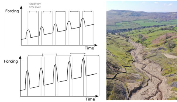
Figure 1: Conceptual diagram showing the recovery timescale and return to background forcing following an extreme event (upper-left panel). Lower-left panel shows a scenario with a larger magnitude event, possibly as a result of a changing climate, and a corresponding longer recovery timescale such that the next extreme event occurs before full recovery has been achieved (from Baynes et al. 2018). Right panel: Impact of a flash flood on a river in the Yorkshire Dales (from Baynes et al. 2023).
Host
Loughborough UniversityTheme
- Climate and Environmental Sustainability
- Dynamic Earth
Supervisors
Project investigator
Dr Edwin Baynes; Loughborough University: [email protected]
Co-investigators
Dr Matthew Baddock; Loughborough University: [email protected]
Prof Daniel Parsons; Loughborough University: [email protected]
How to apply
- Each host has a slightly different application process.
Find out how to apply for this studentship. - All applications must include the CENTA application form. Choose your application route
Methodology
The primary methodology for this PhD will be mapping landscape change using satellite imagery (e.g., Landsat or Sentinel 2 imagery) in a GIS environment (e.g., Google Earth Engine; Boothroyd et al., 2021; Leenman et al., 2023) to determine variability in the rates of landscape change through time since an extreme event. This mapping will be complemented by innovative topographic analysis, fieldwork and numerical modelling using established numerical algorithms and Digital Elevation Models (e.g., Topotoolbox; Schwanghart and Scherler, 2014 and Caesar-Lisflood; Coulthard et al., 2013) to determine key landscape controls that set the recovery timescale following particular events. Field data will be collected to ground-truth the remote-sensing analysis, depending on the selected study locations that will be determined by the student in the first year of the PhD.
Training and skills
Students will be awarded CENTA2 Training Credits (CTCs) for participation in CENTA2-provided and ‘free choice’ external training. One CTC equates to 1⁄2 day session and students must accrue 100 CTCs across the three years of their PhD.
The project will forge strong skills in handling, organising, and analysing large volumes of topographic and remotely sensed data. Training will be provided in topographic analysis and numerical modelling techniques as well as necessary GIS and coding skills as required. Analysis and interpretation of the datasets will lead to the development of high-level skills in statistics. The combination of GIS, topographic analysis, coding, data handling and data analysis skills provides an outstanding training opportunity.
Partners and collaboration
Dr Anya Leenman, Victoria University of Wellington, New Zealand is a project partner, bringing technical expertise in analysing large scale geomorphological datasets and insight into extreme events based in New Zealand.
Further details
Further details on how to contact the supervisor for this project and how to apply for this project can be found here:
For any enquiries related to this project please contact Dr Edwin Baynes ([email protected]).
To apply to this project:
- You must include a CENTA studentship application form, downloadable from: CENTA Studentship Application Form 2024.
- You must include a CV with the names of at least two referees (preferably three) who can comment on your academic abilities.
- Please submit your application and complete the host institution application process via: https://www.lboro.ac.uk/study/postgraduate/apply/research-applications/ The CENTA application form 2024 and CV can be uploaded at Section 10 “Supporting Documents” of the online portal. Under Section 4 “Programme Selection” the proposed study centre is Central England NERC Training Alliance. Please quote CENTA 2024-LU2 when completing the application form.
- For further enquiries about the application process, please contact the School of Social Sciences & Humanities ([email protected]).
Applications must be submitted by 23:59 GMT on Wednesday 10th January 2024.
Possible timeline
Year 1
The student will familiarise themselves with and use cutting edge computational topographic analysis, remote sensing and numerical modelling packages applied within geomorphology studies (e.g., Google Earth Engine; Boothroyd et al., 2021). The student will also identify the sites and discrete extreme events for study (e.g., UK and/or New Zealand).
Year 2
Mapping, modelling, and quantification of rates of landscape change and landscape recovery using satellite imagery. Comparisons to be made between recovery timescales of different landscapes and extreme events.
Year 3
Synthesis of landscape recovery in the context of changing frequency and magnitude of extreme events in the future.
Further reading
Baynes E.R.C., Attal M., Niedermann S., Kirstein L.A., Dugmore A.J., Naylor M. (2015) ‘Erosion during extreme flood events dominates Holocene canyon evolution in northeast Iceland’. Proceedings of the National Academy of Sciences 112 (8), 2355-2360.
Baynes E.R.C., van de Lageweg W.I., McLelland S.J., Parsons D.P., Aberle J., Dijkstra J., Henry P-Y., Rice S.P., Thom M., Moulin F. (2018) ‘Beyond equilibrium: Re-evaluating physical modelling of fluvial systems to represent climate changes’. Earth-Science Reviews 181, 82-97.
Baynes E.R.C., Kincey M.E., Warburton J. (2023) ‘Extreme Flood Sediment Production and Export Controlled by Reach-Scale Morphology’. Geophysical Research Letters, 50 (10), e2023GL103042.
Boothroyd R.J., Williams R.D., Hoey T.B., Barrett B., Prasajo O.A. (2021) ‘Applications of Google Earth Engine in fluvial geomorphology for detecting river channel change’. WIREs Water 9, e21496.
Coulthard T.J., Neal, J.C., Bates, P.D., Ramirez J., de Almeida G.A.M., Hancock G.R. (2013) ‘Integrating the LISFLOOD-FP 2D hydrodynamic model with the CAESAR model: implications for modelling landscape evolution’. Earth Surface Processes and Landforms 38, 1897-1906
Hovius N., Meunier P., Ching-Weei L., Hongey C., Yue-Gau C., Dadson S., Ming-Jame H., Lines M. (2011) ‘Prolonged seismically induced erosion and the mass balance of a large earthquake’. Earth and Planetary Science Letters 304 (3-4), 347-355.
Leenman A.S., Slater L.J., Dadson S.J., Wortmann M., Boothroyd R., (2023) ‘Quantifying the geomorphic effect of floods using satellite observations of river mobility’. Geophysical Research Letters 50 (16), e2023GL103875
Marc O., Hovius N., Meunier P., Uchida T., Hayashi S-I., (2015) ‘Transient changes of landslide rates after earthquakes’ Geology 43 (10), 883-886.
Schwanghart, W., Scherler, D. (2014) ‘TopoToolbox 2 – MATLAB-based software for topographic analysis and modeling in Earth surface sciences’. Earth Surface Dynamics, 2, 1-7.
Tunnicliffe J., Brierley G., Fuller I.C., Leenman A., Marden M., Peacock D., (2018) ‘Reaction and relaxation in a coarse-grained fluvial system following catchment-wide disturbance’. Geomorphology 307, 50-64.
Westoby M.J., Dunning S.A., Carrivick J.L., Coulthard T.J., Sain K., Kumar A., Berthier E., Haritashya U.K., Shean D.E., Farooq Azam M., Upadhyay K., Koppes M., McCourth H.R., Shugar D.H., (2023) ‘Rapid fluvial remobilization of sediments deposited by the 2021 Chamoli disaster, Indian Himalaya’. Geology https://doi.org/10.1130/G51225.1