Project highlights
- Effect of herbicides on biodiversity of floodplain meadows situated in the same river valley as arable fields, is largely unknown
- Herbicides can have long lasting effect being deposited in the river sediments and re-distributed across floodplain landscape with floods, preventing meadow restoration.
- Lack of plant species propagules in the landscape can be caused by earlier herbicide applications.
Overview
Selective herbicides have been widely used in agriculture to control weeds both in arable crops and in improved meadows and pastures. Herbicides destroy Dicotyledons while grasses have advantage to grow. This effect appeared to be long lasting. Even recorded half-life of herbicides appeared not very long, e.g., 2,4-D breaks down in soil in 1-14 days, however, some forms had a much longer half-life in aquatic sediment of 186 days (Gervais et al, 2008). Another very widely used herbicide Atrazine has a half-life of around 578 days in anoxic conditions (Hanson et al, 2020). However, the fields, which didn’t receive herbicides for 5 and more years remain mostly grassy. Some meadows, according to their owners’ records, never received herbicides, however their swards contain grasses only. Attempts to restore species rich plant communities in such meadows give poor results.
Herbicides often contaminate non-target sites (Schreiber et al, 2018). The herbicides were detected remaining in ground water, river sediments and anoxic soils for much longer than in the dry soils. Flood water going across river valley can re-distribute herbicides from the river sediments as much as from the neighbouring arable fields, where herbicides are applied annually. While effect of nutrients brought into the species-rich floodplain meadows with flood sediments, is well understood (Rothero et al, 2016), there is little knowledge on distribution of herbicides within a floodplain system.
The project aims to measure effect of herbicides on ancient floodplain meadows and on restoration meadows.
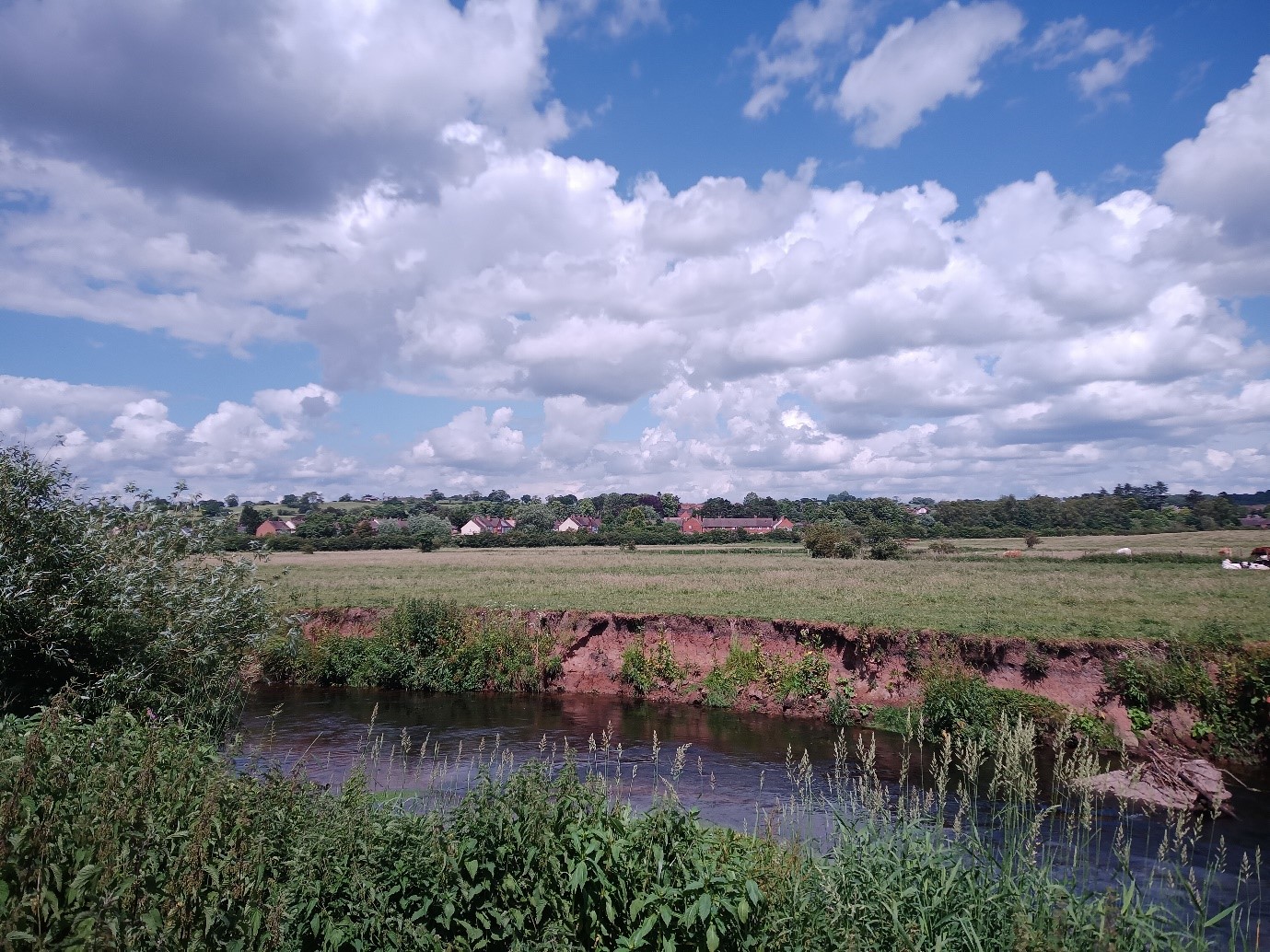
Figure 1: Floodplain meadow restoration in the river Wye valley. The photo shows a meadow situated in the River Wye floodplain with a village at the distance. No brightly colored flowers can be seen in vegetation, which is dominated by grasses. The river bank exposes Old Red Sandstone type soils underlying the meadow.
CENTA Flagship
This is a CENTA Flagship Project
Host
The Open UniversityTheme
- Climate and Environmental Sustainability
- Organisms and Ecosystems
Supervisors
Project investigator
Dr Irina Tatarenko, Open University
Co-investigators
Dr David Gowing, Open University
How to apply
- Each host has a slightly different application process.
Find out how to apply for this studentship. - All applications must include the CENTA application form. Choose your application route
Methodology
Suggested study site is located in the River Wye floodplain. Local Wildlife Trust and Meadow Conservation group are interested in the study and will provide support in arranging access permissions to the particular fields.
Fieldwork will include sample collection from the soil and from the river sediments. Experimental methods to evaluate herbicides behaviour in soil will be selected after identification of soil types in the River Wye floodplain. Chemical tests will be carried out at the Lab.
Another part of fieldwork will include botanical surveys of selected fields in June-July, plant species and their abundance will be recorded in 1×1 m plots randomly located across the field.
Some areas of the meadows will be identified for meadow restoration experiments. Forbs seeds will be sown to test effects of soil on young seedlings. Experimental plots will be revisited through the year to monitor germination rates.
Training and skills
Students will be awarded CENTA2 Training Credits (CTCs) for participation in CENTA2-provided and ‘free choice’ external training. One CTC equates to 1⁄2 day session and students must accrue 100 CTCs across the three years of their PhD.
Student will learn a range of environment survey skills: plant ID, botanical survey, soil survey, and water survey techniques along with working with large datasets.
Partners and collaboration
Both potential partners have been contacted and have expressed an interest, but with the Rivers Trust being so new to the CENTA partnership they have not had the opportunity to fully consider the opportunity yet.
Further details
Further details on how to contact the supervisor for this project and how to apply for this project can be found here:
For any enquiries related to this project please contact Dr Irina Tatarenko, Floodplain Meadow Partnership Research coordinator, School of Environment, Earth and Ecosystem Sciences, STEM, Open University, Walton Hall, Milton Keynes, MK76AA, [email protected], http://floodplainmeadows.org.uk/
To apply to this project:
- You must include a CENTA studentship application form, downloadable from: CENTA Studentship Application Form 2024.
- You must include a CV with the names of at least two referees (preferably three) who can comment on your academic abilities.
- Your application materials, including the CENTA application form 2024, your CV and the Open University application form must be emailed to [email protected]. Instructions on how to apply to the Open University are to be found on https://www5.open.ac.uk/stem/environment-earth-ecosystem-sciences/research/phd-students/current-opportunities-and-how-apply, please ensure you read this webpage before applying as you will need to obtain the relevant OU application form from here. Please quote CENTA 2024-OU1 when completing the application form.
Applications must be submitted by 23:59 GMT on Wednesday 10th January 2024.
Possible timeline
Year 1
Literature review. Planning experimental design. Fieldwork: collection of soil, sediments and water samples to analyse presence/concentration of herbicides. Botanical surveys of the meadows. Field experiments on meadow restoration.
Year 2
Re-survey of the field experimental plots. Data analysis.
Year 3
Re-survey of the field experimental plots. Data analysis, thesis preparation.
Further reading
Boivin, A., Amellal, S., Schiavon, M., van Genuchten, M.T. (2005) 2,4-dichlorophenoxyacetic acid (2,4-D) sorption and degradation dynamics in three agricultural soils. Environ. Pollut. 138, pp. 92-99.
Gervais, J., Luukinen, B., Buhl, K., Stone, D. (2008) ‘2,4-D Technical Fact Sheet’ National Pesticide Information Center, Oregon State University Extension Services. Available at: http://npic.orst.edu/factsheets/archive/2,4-DTech.html (Accessed: 11 September 2023).
Hanson, W., Strid, A., Gervais, J., Cross, A., Jenkins, J. (2020) ‘Atrazine Fact Sheet’ National Pesticide Information Center, Oregon State University Extension Services. Available at: http://npic.orst.edu/factsheets/atrazine.html#env (Accessed:10 September 2023).
McPherson, A. K.; Moreland, R. S.; Atkins, J. B. (2003) Occurrence and Distribution of Nutrients, Suspended Sediment, and Pesticides in the Mobile River Basin, Alabama, Georgia, Mississippi, and Tennessee, 1999-2001; Water-Resources Investigations Report 03- 4203, U.S. Geological Survey: Montgomery, AL, pp 1-2, 44, 57.
Mueller, T.C., Senseman, S.A. (2015) Methods Related to Herbicide Dissipation or Degradation under Field or Laboratory Conditions. Weed Science 2015 Special Issue, pp. 133–139.
Ney, R.E. (1995) Fate and Transport of Organic Chemicals in the Environment, 2nd ed.; Government Institutes, Inc.: Rockville, MD.
Pesticides in Surface and Groundwater of the United States: Summary of Results of the National Water Quality Assessment Program (NAWQA); U.S. Geological Survey: Reston, VA, 1998.
Rothero, E., Lake, S. and Gowing, D. (eds) (2016) ‘Floodplain Meadows – Beauty and Utility’. A Technical Handbook. Milton Keynes, Floodplain Meadows Partnership.
Schreiber, F., Scherner, A., Andres, A., Concenço, G., Ceolin, W.C., Martins, M.B. (2018) Experimental methods to evaluate herbicides behaviour in soil. Revista Brasileira de Herbicidas, 17 (1), pp.71-85, DOI: https://doi.org/10.7824/rbh.v17i1.540
Wilson, R. D.; Geronimo, J.; Armbruster, J. A. (1997) 2,4-D Dissipation in Field Soils After Applications of 2,4-Dimethylamine Salt and 2,4-D Ethylhexyl Ester. Environ. Toxicol. Chem. 16 (6), pp. 1239-1246.