Project highlights
- The project will create new high-resolution landscape information
- Advance the use of AI for habitat prediction from aerial and satellite imagery
- Improve understanding of species distribution and movement and effectively target resources for nature recovery
Overview
This research aims to automate the production of high-resolution habitat maps for diversity monitoring across UK landscapes. Accurate, scale dependant, information on habit location and condition is essential for understanding species distribution and movement, and to effectively target resources for nature recovery. This is urgent as there has been a significant loss of biodiversity within the UK, with a 60% decline in the abundance of UK priority species since 1970.
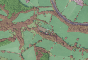
Recent advances in image-based AI allow us to evaluate the extent and distribution of habitats faster, more efficiently and with higher accuracy (van de Plas et al 2023, see figure 1). However, the variation in landcover caused by climate, seasonality and management requires a corpus of examples to train robust models. When combined with the limitations of image data collection (variation in timing, resolution, quality) and the semantics of habitat types, the lack of a high quality, representative datasets are a major limitation to the scaling of high-resolution predictions to the whole of the terrestrial UK (or globally).
This project aims to create an predictive model for UK landscapes through: 1) investigating the scaling of small, project specific datasets for Machine Learning to large scale datasets suitable for training models with high generalisation, 2) evaluating the training performance of fully supervised, semi- and unsupervised training methods, 3) evaluating the effect of image resolution and timing on model predictions, and 4) critically evaluating model outputs for monitoring biodiversity. The project is supported by the Peak District National Park Authority, with image data supplied by Aerial Photography GB and Airbus Defence and Space.
Figure 1: Landscape information at high resolution from a landcover segmentation model (see van de Plas et al 2023) using aerial photography at 12.5 cm resolution. Background image Aerial Photography Great Britain.
Case funding
This project is suitable for CASE funding
Host
Cranfield UniversityTheme
- Climate and Environmental Sustainability
- Organisms and Ecosystems
Supervisors
Project investigator
- Daniel Simms, Cranfield University, ([email protected])
Co-investigators
- Toby Waine, Cranfield University, ([email protected])
How to apply
- Each host has a slightly different application process.
Find out how to apply for this studentship. - All applications must include the CENTA application form. Choose your application route
Methodology
The approach will be to evaluate deep-learning models for landscape prediction using supervised, semi- and unsupervised training methods. To do this the DR will bring together a wide range of existing labelled datasets (project level data) and large volumes of unlabelled image data from satellite and aerial photography at a range of spatial resolutions through time. The project will investigate model architectures, such as Autoencoders, Transformers and Generative Adversarial Networks, for their ability to generalise to new landscapes and the effects of error and bias on landcover predictions at scale.
Training and skills
DRs will be awarded CENTA Training Credits (CTCs) for participation in CENTA-provided and ‘free choice’ external training. One CTC can be earned per 3 hours training, and DRs must accrue 100 CTCs across the three and a half years of their PhD.
Extra training in AI tools and machine learning pipelines for aerial and satellite datasets will be provided alongside the wider CENTA training. Field skills in habitat survey in support of image interpretation will be gained during placement at the Peak District National Park Authority.
Partners and collaboration
The Peak District National Park Authority (PDNP) is exploring new technologies aimed at tackling the challenge of precise monitoring and strategic planning for nature at a landscape scale. They will provide supervision and a 6-to-12-month placement, where the DR will work embedded within the research team.
Further details
For any enquiries related to this project please contact Dr Daniel Simms, Cranfield Environment Centre, [email protected].
To apply to this project:
- You must include a CENTA studentship application form, downloadable from: CENTA Studentship Application Form 2025.
- You must include a CV with the names of at least two referees (preferably three) who can comment on your academic abilities.
- Please submit your application and complete the host institution application process via: https://www.cranfield.ac.uk/research/phd/uk-digital-ecological-landscapes. The CENTA Studentship Application Form 2025 can be uploaded to the Personal Statement section of the online form, the CV can be uploaded to the experience section. Your application must state the reference CENTA 2025-C1 and SWEE0272.
Applications must be submitted by 23:59 GMT on Wednesday 8th January 2025.
Possible timeline
Year 1
Literature review, and data search, collection and curation. Training in research methods, remote sensing and machine learning.
Year 2
Critical evaluation of models and training approaches for landscape/habitat prediction at scale. Placement at Peak District National Park Authority.
Year 3
Synthesis, presentation of findings at conference(s) and thesis writing.
Further reading
van der Plas, T. L., Geikie, S. T., Alexander, D. G., & Simms, D. M. (2023). Multi-Stage Semantic Segmentation Quantifies Fragmentation of Small Habitats at a Landscape Scale. Remote Sensing, 15(22), 5277. https://doi.org/10.3390/rs15225277

